Dzierzążnia geodata
Dzierzążnia (Mazovia) is a seat of a third-order administrative division; located in Poland in Europe/Warsaw (GMT+2) time zone. With population of 442 people, there are 3571 cities with bigger population in this country. Compared to other cities in Poland, 78.3% of cities are located further ↓South; 61.6% of cities are located further ←West and 75.8% of cities have higher elevation than Dzierzążnia. Note1


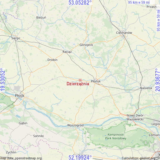
Dzierzążnia GPS coordinates[2]
52° 37' 41.196" North, 20° 14' 1.104" East
| Map corner | latitude | longitude |
|---|---|---|
| Upper-left | 53.05282°, | 19.53052° |
| Center: | 52.62811°, | 20.23364° |
| Lower-right: | 52.19924°, | 20.93677° |
| Map W x H: | 94.9×94.9 km | = 59×59mi |
| max Lat: | 54.83135° ⇑21.7% North |
| Dzierzążnia: | 52.62811° |
| min Lat: | ⇓78.3% South 49.21328° |
| min Long | Dzierzążnia | max Long |
| 14.20249° | 20.23364° | 24.03723° |
| W 61.6%⇐ | ⇒38.4% E |
Elevation
Elevation of Dzierzążnia is 109 m = 358 ft, and this is 82.4 m = 270 ft below average elevation for this country.
| Max E: |
974 m = 3196 ft | 75.8% |
| Avg. | 191.4 m = 628 ft | |
| Dzierzążnia | 109 m = 358 ft | |
Min E: |
-3 m = -10 ft | 24.2% |
See also: Poland elevation on elevation.city.
Geographical zone
Dzierzążnia is located in North temperate zone (between Tropic of Cancer and the Arctic Circle). Distance of this North polar circle is 1549.5 km =962.8 mi to North.| Distance of | km | miles | from Dzierzążnia |
|---|---|---|---|
| North Pole | 4155.4 | 2582 | to North |
| Arctic Circle | 1549.5 | 962.8 | to North |
| Tropic Cancer | 3245.8 | 2016.8 | to South |
| Equator | 5851.7 | 3636.1 | to South |


Nearby cities:
15 places around Dzierzążnia: (largest is in red/bold)
• Baboszewo
6 km =3.7 mi,  14°
14°
• Bodzanów
19.8 km =12.3 mi,  224°
224°
• Bulkowo
12.4 km =7.7 mi, 218°
• Drobin
20.5 km =12.7 mi,  306°
306°
• Glinojeck
21.7 km =13.5 mi, 10°
• Joniec
23.7 km =14.7 mi,  97°
97°
• Mała Wieś
20.9 km =13 mi,  205°
205°
• Naruszewo
13.8 km =8.6 mi,  144°
144°
• Ojrzeń
25.9 km =16.1 mi,  53°
53°
• Płońsk
9.6 km =6 mi,  93°
93°
• Raciąż
18.8 km =11.7 mi,  335°
335°
• Radzanowo
23.9 km =14.9 mi,  255°
255°
• Sochocin
17.4 km =10.8 mi,  67°
67°
• Staroźreby
16.8 km =10.4 mi,  271°
271°
• Załuski
23.8 km =14.8 mi,  123°
123°
Sources, notices
• [Note1] Compared only with cities in Poland existing in our database
• [Src1] Map data: © OpenStreetMap contributors (CC-BY-SA)
• [Src2] Other city data from geonames.org with taken over terms of usage.
• [Src3] Geographical zone / Annual Mean Temperature by Robert A. Rohde @ Wikipedia
