Jabłonica geodata
Jabłonica (Subcarpathian) is a populated place; located in Poland in Europe/Warsaw (GMT+2) time zone. With population of 680 people, there are 3110 cities with bigger population in this country. Compared to other cities in Poland, 92% of cities are located further ↑North; 77.2% of cities are located further ←West and 87.8% of cities have lower elevation than Jabłonica. Note1


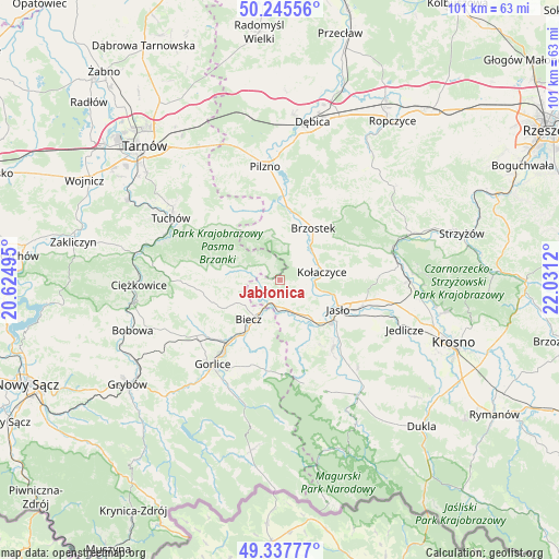
Jabłonica GPS coordinates[2]
49° 47' 37.644" North, 21° 19' 41.052" East
| Map corner | latitude | longitude |
|---|---|---|
| Upper-left | 50.24556°, | 20.62495° |
| Center: | 49.79379°, | 21.32807° |
| Lower-right: | 49.33777°, | 22.0312° |
| Map W x H: | 100.9×100.9 km | = 62.7×62.7mi |
| max Lat: | 54.83135° ⇑92% North |
| Jabłonica: | 49.79379° |
| min Lat: | ⇓8% South 49.21328° |
| min Long | Jabłonica | max Long |
| 14.20249° | 21.32807° | 24.03723° |
| W 77.2%⇐ | ⇒22.8% E |
Elevation
Elevation of Jabłonica is 307 m = 1007 ft, and this is 115.6 m = 379 ft above average elevation for this country.
| Max E: |
974 m = 3196 ft | 12.2% |
| Jabłonica | 307 m 1007 ft | |
| Avg. | 191.4 m = 628 ft | |
Min E: |
-3 m = -10 ft | 87.8% |
See also: Poland elevation on elevation.city.
Geographical zone
Jabłonica is located in North temperate zone (between Tropic of Cancer and the Arctic Circle). Distance of this North polar circle is 1864.6 km =1158.6 mi to North.| Distance of | km | miles | from Jabłonica |
|---|---|---|---|
| North Pole | 4470.5 | 2777.8 | to North |
| Arctic Circle | 1864.6 | 1158.6 | to North |
| Tropic Cancer | 2930.6 | 1821 | to South |
| Equator | 5536.6 | 3440.3 | to South |


Nearby cities:
15 places around Jabłonica: (largest is in red/bold)
• Biecz
7.9 km =4.9 mi,  216°
216°
• Binarowa
8.3 km =5.2 mi,  239°
239°
• Brzostek
11.2 km =7 mi,  31°
31°
• Brzyska
5.5 km =3.4 mi,  54°
54°
• Jasło
11.7 km =7.3 mi,  117°
117°
• Jodłowa
9.4 km =5.8 mi,  338°
338°
• Korczyna
10.6 km =6.6 mi,  211°
211°
• Kołaczyce
7.8 km =4.8 mi,  78°
78°
• Lipnica Dolna
4.2 km =2.6 mi,  106°
106°
• Ołpiny
9 km =5.6 mi,  279°
279°
• Racławice
11.1 km =6.9 mi, 243°
• Skołyszyn
5 km =3.1 mi,  172°
172°
• Szerzyny
6.1 km =3.8 mi,  286°
286°
• Trzcinica
8.6 km =5.3 mi,  131°
131°
• Wróblowa
5.1 km =3.2 mi,  94°
94°
Sources, notices
• [Note1] Compared only with cities in Poland existing in our database
• [Src1] Map data: © OpenStreetMap contributors (CC-BY-SA)
• [Src2] Other city data from geonames.org with taken over terms of usage.
• [Src3] Geographical zone / Annual Mean Temperature by Robert A. Rohde @ Wikipedia
