Żółkiewka geodata
Żółkiewka (Lublin) is a seat of a third-order administrative division; located in Poland in Europe/Warsaw (GMT+2) time zone. With population of 790 people, there are 2877 cities with bigger population in this country. Compared to other cities in Poland, 57.4% of cities are located further ↑North; 94.8% of cities are located further ←West and 68.7% of cities have lower elevation than Żółkiewka. Note1


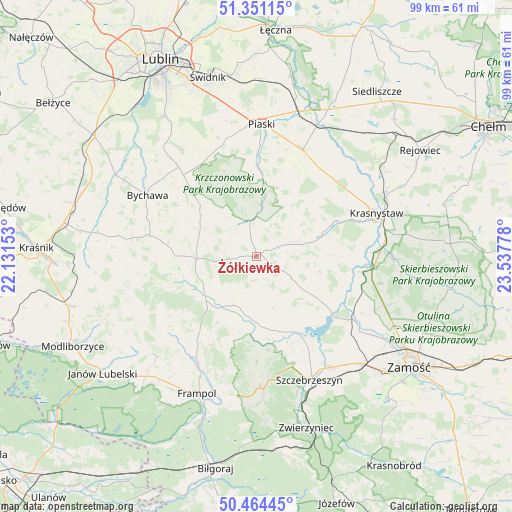
Żółkiewka GPS coordinates[2]
50° 54' 35.676" North, 22° 50' 4.74" East
| Map corner | latitude | longitude |
|---|---|---|
| Upper-left | 51.35115°, | 22.13153° |
| Center: | 50.90991°, | 22.83465° |
| Lower-right: | 50.46445°, | 23.53778° |
| Map W x H: | 98.6×98.6 km | = 61.3×61.3mi |
| max Lat: | 54.83135° ⇑57.4% North |
| Żółkiewka: | 50.90991° |
| min Lat: | ⇓42.6% South 49.21328° |
| min Long | Żółkiewka | max Long |
| 14.20249° | 22.83465° | 24.03723° |
| W 94.8%⇐ | ⇒5.2% E |
Elevation
Elevation of Żółkiewka is 225 m = 738 ft, and this is 33.6 m = 110 ft above average elevation for this country.
| Max E: |
974 m = 3196 ft | 31.3% |
| Żółkiewka | 225 m 738 ft | |
| Avg. | 191.4 m = 628 ft | |
Min E: |
-3 m = -10 ft | 68.7% |
See also: Poland elevation on elevation.city.
Geographical zone
Żółkiewka is located in North temperate zone (between Tropic of Cancer and the Arctic Circle). Distance of this North polar circle is 1740.5 km =1081.5 mi to North.| Distance of | km | miles | from Żółkiewka |
|---|---|---|---|
| North Pole | 4346.4 | 2700.7 | to North |
| Arctic Circle | 1740.5 | 1081.5 | to North |
| Tropic Cancer | 3054.7 | 1898.1 | to South |
| Equator | 5660.7 | 3517.4 | to South |


Nearby cities:
15 places around Żółkiewka: (largest is in red/bold)
• Chrzanów
22.3 km =13.9 mi,  226°
226°
• Gorzków
13.2 km =8.2 mi,  71°
71°
• Izbica
22.4 km =13.9 mi,  96°
96°
• Krzczonów
13.9 km =8.6 mi,  321°
321°
• Nielisz
19.1 km =11.9 mi,  129°
129°
• Olszanka
18.8 km =11.7 mi,  43°
43°
• Radecznica
17.6 km =10.9 mi,  181°
181°
• Rudnik
10.2 km =6.3 mi,  108°
108°
• Rybczewice
13.3 km =8.3 mi,  4°
4°
• Sułów
17.6 km =10.9 mi,  151°
151°
• Turobin
11.6 km =7.2 mi,  213°
213°
• Wysokie
11.8 km =7.3 mi,  270°
270°
• Zakrzew
17.2 km =10.7 mi,  262°
262°
• Łopiennik Górny
19.4 km =12.1 mi, 41°
• Żabno
7.6 km =4.7 mi, 214°
Sources, notices
• [Note1] Compared only with cities in Poland existing in our database
• [Src1] Map data: © OpenStreetMap contributors (CC-BY-SA)
• [Src2] Other city data from geonames.org with taken over terms of usage.
• [Src3] Geographical zone / Annual Mean Temperature by Robert A. Rohde @ Wikipedia
