Żabno geodata
Żabno (Lublin) is a populated place; located in Poland in Europe/Warsaw (GMT+2) time zone. With population of 536 people, there are 3445 cities with bigger population in this country. Compared to other cities in Poland, 58.9% of cities are located further ↑North; 94.4% of cities are located further ←West and 67.4% of cities have lower elevation than Żabno. Note1


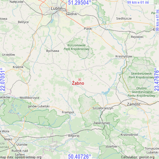
Żabno GPS coordinates[2]
50° 51' 11.736" North, 22° 46' 25.068" East
| Map corner | latitude | longitude |
|---|---|---|
| Upper-left | 51.29504°, | 22.07051° |
| Center: | 50.85326°, | 22.77363° |
| Lower-right: | 50.40726°, | 23.47676° |
| Map W x H: | 98.7×98.7 km | = 61.3×61.3mi |
| max Lat: | 54.83135° ⇑58.9% North |
| Żabno: | 50.85326° |
| min Lat: | ⇓41.1% South 49.21328° |
| min Long | Żabno | max Long |
| 14.20249° | 22.77363° | 24.03723° |
| W 94.4%⇐ | ⇒5.6% E |
Elevation
Elevation of Żabno is 221 m = 725 ft, and this is 29.6 m = 97 ft above average elevation for this country.
| Max E: |
974 m = 3196 ft | 32.6% |
| Żabno | 221 m 725 ft | |
| Avg. | 191.4 m = 628 ft | |
Min E: |
-3 m = -10 ft | 67.4% |
See also: Poland elevation on elevation.city.
Geographical zone
Żabno is located in North temperate zone (between Tropic of Cancer and the Arctic Circle). Distance of this North polar circle is 1746.8 km =1085.4 mi to North.| Distance of | km | miles | from Żabno |
|---|---|---|---|
| North Pole | 4352.7 | 2704.6 | to North |
| Arctic Circle | 1746.8 | 1085.4 | to North |
| Tropic Cancer | 3048.4 | 1894.2 | to South |
| Equator | 5654.4 | 3513.5 | to South |


Nearby cities:
15 places around Żabno: (largest is in red/bold)
• Batorz
19.7 km =12.2 mi,  269°
269°
• Chrzanów
14.9 km =9.3 mi,  233°
233°
• Frampol
21.5 km =13.4 mi,  199°
199°
• Goraj
16.4 km =10.2 mi,  207°
207°
• Gorzków
19.8 km =12.3 mi,  57°
57°
• Krzczonów
17.7 km =11 mi,  345°
345°
• Nielisz
19.9 km =12.4 mi,  107°
107°
• Radecznica
12 km =7.5 mi,  160°
160°
• Rudnik
14.3 km =8.9 mi,  77°
77°
• Rybczewice
20.2 km =12.6 mi,  15°
15°
• Sułów
15.7 km =9.8 mi,  125°
125°
• Turobin
3.9 km =2.4 mi, 213°
• Wysokie
9.9 km =6.2 mi,  310°
310°
• Zakrzew
13.4 km =8.3 mi,  287°
287°
• Żółkiewka
7.6 km =4.7 mi,  34°
34°
Sources, notices
• [Note1] Compared only with cities in Poland existing in our database
• [Src1] Map data: © OpenStreetMap contributors (CC-BY-SA)
• [Src2] Other city data from geonames.org with taken over terms of usage.
• [Src3] Geographical zone / Annual Mean Temperature by Robert A. Rohde @ Wikipedia
