Wysokie geodata
Wysokie (Lublin) is a seat of a third-order administrative division; located in Poland in Europe/Warsaw (GMT+2) time zone. With population of 602 people, there are 3267 cities with bigger population in this country. Compared to other cities in Poland, 57.3% of cities are located further ↑North; 93.5% of cities are located further ←West and 73.4% of cities have lower elevation than Wysokie. Note1


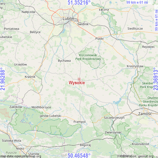
Wysokie GPS coordinates[2]
50° 54' 39.348" North, 22° 39' 57.6" East
| Map corner | latitude | longitude |
|---|---|---|
| Upper-left | 51.35216°, | 21.96288° |
| Center: | 50.91093°, | 22.666° |
| Lower-right: | 50.46548°, | 23.36913° |
| Map W x H: | 98.6×98.6 km | = 61.3×61.3mi |
| max Lat: | 54.83135° ⇑57.3% North |
| Wysokie: | 50.91093° |
| min Lat: | ⇓42.7% South 49.21328° |
| min Long | Wysokie | max Long |
| 14.20249° | 22.666° | 24.03723° |
| W 93.5%⇐ | ⇒6.5% E |
Elevation
Elevation of Wysokie is 241 m = 791 ft, and this is 49.6 m = 163 ft above average elevation for this country.
| Max E: |
974 m = 3196 ft | 26.6% |
| Wysokie | 241 m 791 ft | |
| Avg. | 191.4 m = 628 ft | |
Min E: |
-3 m = -10 ft | 73.4% |
See also: Poland elevation on elevation.city.
Geographical zone
Wysokie is located in North temperate zone (between Tropic of Cancer and the Arctic Circle). Distance of this North polar circle is 1740.4 km =1081.4 mi to North.| Distance of | km | miles | from Wysokie |
|---|---|---|---|
| North Pole | 4346.3 | 2700.7 | to North |
| Arctic Circle | 1740.4 | 1081.4 | to North |
| Tropic Cancer | 3054.8 | 1898.2 | to South |
| Equator | 5660.8 | 3517.5 | to South |


Nearby cities:
15 places around Wysokie: (largest is in red/bold)
• Batorz
13.9 km =8.6 mi,  241°
241°
• Bychawa
14.9 km =9.3 mi,  321°
321°
• Bystrzyca
20.1 km =12.5 mi,  295°
295°
• Chrzanów
16 km =9.9 mi,  195°
195°
• Goraj
21 km =13 mi,  179°
179°
• Jabłonna
20.4 km =12.7 mi,  345°
345°
• Krzczonów
11.2 km =7 mi,  16°
16°
• Radecznica
21.1 km =13.1 mi,  147°
147°
• Rudnik Pierwszy
16.9 km =10.5 mi,  289°
289°
• Rybczewice
18.4 km =11.4 mi,  44°
44°
• Turobin
11.1 km =6.9 mi, 150°
• Zakrzew
5.7 km =3.5 mi,  246°
246°
• Zakrzówek
20.4 km =12.7 mi,  282°
282°
• Żabno
9.9 km =6.2 mi,  130°
130°
• Żółkiewka
11.8 km =7.3 mi,  90°
90°
Sources, notices
• [Note1] Compared only with cities in Poland existing in our database
• [Src1] Map data: © OpenStreetMap contributors (CC-BY-SA)
• [Src2] Other city data from geonames.org with taken over terms of usage.
• [Src3] Geographical zone / Annual Mean Temperature by Robert A. Rohde @ Wikipedia
