Sandomierz geodata
Sandomierz (Świętokrzyskie) is a seat of a second-order administrative division; located in Poland in Europe/Warsaw (GMT+2) time zone. With population of 25,087 people, there are 194 cities with bigger population in this country. Compared to other cities in Poland, 63% of cities are located further ↑North; 81.7% of cities are located further ←West and 55% of cities have lower elevation than Sandomierz. Note1
Administrative division(s):
- Level 1: Świętokrzyskie
- Level 2: Powiat sandomierski
- Level 3: Sandomierz


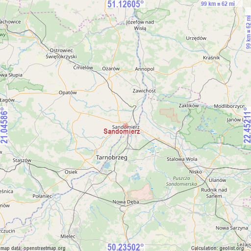
Sandomierz GPS coordinates[2]
50° 40' 57.54" North, 21° 44' 56.328" East
| Map corner | latitude | longitude |
|---|---|---|
| Upper-left | 51.12605°, | 21.04586° |
| Center: | 50.68265°, | 21.74898° |
| Lower-right: | 50.23502°, | 22.45211° |
| Map W x H: | 99.1×99.1 km | = 61.6×61.6mi |
| max Lat: | 54.83135° ⇑63% North |
| Sandomierz: | 50.68265° |
| min Lat: | ⇓37% South 49.21328° |
| min Long | Sandomierz | max Long |
| 14.20249° | 21.74898° | 24.03723° |
| W 81.7%⇐ | ⇒18.3% E |
Elevation
Elevation of Sandomierz is 185 m = 607 ft, and this is 6.4 m = 21 ft below average elevation for this country.
| Max E: |
974 m = 3196 ft | 45% |
| Avg. | 191.4 m = 628 ft | |
| Sandomierz | 185 m = 607 ft | |
Min E: |
-3 m = -10 ft | 55% |
See also: Poland elevation on elevation.city.
Geographical zone
Sandomierz is located in North temperate zone (between Tropic of Cancer and the Arctic Circle). Distance of this North polar circle is 1765.8 km =1097.2 mi to North.| Distance of | km | miles | from Sandomierz |
|---|---|---|---|
| North Pole | 4371.7 | 2716.4 | to North |
| Arctic Circle | 1765.8 | 1097.2 | to North |
| Tropic Cancer | 3029.5 | 1882.4 | to South |
| Equator | 5635.4 | 3501.7 | to South |


Nearby cities:
15 places around Sandomierz: (largest is in red/bold)
• Chwałowice
13.5 km =8.4 mi,  46°
46°
• Dwikozy
6.6 km =4.1 mi,  25°
25°
• Gorzyce
6.6 km =4.1 mi,  104°
104°
• Koprzywnica
15.3 km =9.5 mi,  229°
229°
• Kępie Żaleszańskie
10.5 km =6.5 mi,  117°
117°
• Obrazów
7 km =4.3 mi,  279°
279°
• Radomyśl
13.7 km =8.5 mi,  90°
90°
• Samborzec
8.2 km =5.1 mi,  240°
240°
• Sobótka
13.6 km =8.5 mi,  337°
337°
• Sokolniki
6.4 km =4 mi,  140°
140°
• Tarnobrzeg
13.1 km =8.1 mi,  201°
201°
• Wilczyce
9.6 km =6 mi,  318°
318°
• Zaleszany
10.7 km =6.6 mi,  111°
111°
• Złota
5.2 km =3.2 mi, 243°
• Żabno
15.5 km =9.6 mi, 92°
Sources, notices
• [Note1] Compared only with cities in Poland existing in our database
• [Src1] Map data: © OpenStreetMap contributors (CC-BY-SA)
• [Src2] Other city data from geonames.org with taken over terms of usage.
• [Src3] Geographical zone / Annual Mean Temperature by Robert A. Rohde @ Wikipedia
