Sobótka geodata
Sobótka (Świętokrzyskie) is a populated place; located in Poland in Europe/Warsaw (GMT+2) time zone. With population of 630 people, there are 3202 cities with bigger population in this country. Compared to other cities in Poland, 60.3% of cities are located further ↑North; 81.1% of cities are located further ←West and 59.2% of cities have lower elevation than Sobótka. Note1


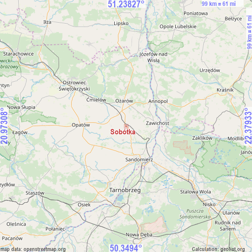
Sobótka GPS coordinates[2]
50° 47' 45.42" North, 21° 40' 34.32" East
| Map corner | latitude | longitude |
|---|---|---|
| Upper-left | 51.23827°, | 20.97308° |
| Center: | 50.79595°, | 21.6762° |
| Lower-right: | 50.3494°, | 22.37933° |
| Map W x H: | 98.8×98.8 km | = 61.4×61.4mi |
| max Lat: | 54.83135° ⇑60.3% North |
| Sobótka: | 50.79595° |
| min Lat: | ⇓39.7% South 49.21328° |
| min Long | Sobótka | max Long |
| 14.20249° | 21.6762° | 24.03723° |
| W 81.1%⇐ | ⇒18.9% E |
Elevation
Elevation of Sobótka is 198 m = 650 ft, and this is 6.6 m = 22 ft above average elevation for this country.
| Max E: |
974 m = 3196 ft | 40.8% |
| Sobótka | 198 m 650 ft | |
| Avg. | 191.4 m = 628 ft | |
Min E: |
-3 m = -10 ft | 59.2% |
See also: Poland elevation on elevation.city.
Geographical zone
Sobótka is located in North temperate zone (between Tropic of Cancer and the Arctic Circle). Distance of this North polar circle is 1753.2 km =1089.4 mi to North.| Distance of | km | miles | from Sobótka |
|---|---|---|---|
| North Pole | 4359.1 | 2708.6 | to North |
| Arctic Circle | 1753.2 | 1089.4 | to North |
| Tropic Cancer | 3042.1 | 1890.3 | to South |
| Equator | 5648 | 3509.5 | to South |


Nearby cities:
15 places around Sobótka: (largest is in red/bold)
• Annopol
16.1 km =10 mi,  51°
51°
• Brzóstowa
17.2 km =10.7 mi,  307°
307°
• Chwałowice
15.2 km =9.4 mi,  102°
102°
• Dwikozy
10.3 km =6.4 mi,  130°
130°
• Lipnik
14.8 km =9.2 mi,  240°
240°
• Obrazów
11.6 km =7.2 mi,  188°
188°
• Opatów
17.6 km =10.9 mi,  271°
271°
• Ożarów
10.3 km =6.4 mi,  356°
356°
• Samborzec
16.7 km =10.4 mi, 186°
• Sandomierz
13.6 km =8.5 mi,  157°
157°
• Wilczyce
5.6 km =3.5 mi, 193°
• Wojciechowice
8 km =5 mi, 310°
• Zawichost
12.6 km =7.8 mi,  84°
84°
• Złota
14.9 km =9.3 mi,  178°
178°
• Ćmielów
15.5 km =9.6 mi, 312°
Sources, notices
• [Note1] Compared only with cities in Poland existing in our database
• [Src1] Map data: © OpenStreetMap contributors (CC-BY-SA)
• [Src2] Other city data from geonames.org with taken over terms of usage.
• [Src3] Geographical zone / Annual Mean Temperature by Robert A. Rohde @ Wikipedia
