Radomyśl geodata
Radomyśl (Subcarpathian) is a seat of a third-order administrative division; located in Poland in Europe/Warsaw (GMT+2) time zone. With population of 808 people, there are 2841 cities with bigger population in this country. Compared to other cities in Poland, 63.1% of cities are located further ↑North; 84% of cities are located further ←West and 60.6% of cities have higher elevation than Radomyśl. Note1
Administrative division(s):
- Level 1: Subcarpathian
- Level 2: Powiat stalowowolski
- Level 3: Radomyśl nad Sanem


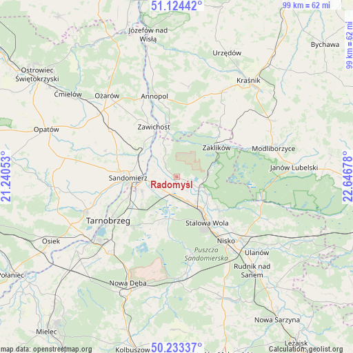
Radomyśl GPS coordinates[2]
50° 40' 51.636" North, 21° 56' 37.14" East
| Map corner | latitude | longitude |
|---|---|---|
| Upper-left | 51.12442°, | 21.24053° |
| Center: | 50.68101°, | 21.94365° |
| Lower-right: | 50.23337°, | 22.64678° |
| Map W x H: | 99.1×99.1 km | = 61.6×61.6mi |
| max Lat: | 54.83135° ⇑63.1% North |
| Radomyśl: | 50.68101° |
| min Lat: | ⇓36.9% South 49.21328° |
| min Long | Radomyśl | max Long |
| 14.20249° | 21.94365° | 24.03723° |
| W 84%⇐ | ⇒16% E |
Elevation
Elevation of Radomyśl is 145 m = 476 ft, and this is 46.4 m = 152 ft below average elevation for this country.
| Max E: |
974 m = 3196 ft | 60.6% |
| Avg. | 191.4 m = 628 ft | |
| Radomyśl | 145 m = 476 ft | |
Min E: |
-3 m = -10 ft | 39.4% |
See also: Poland elevation on elevation.city.
Geographical zone
Radomyśl is located in North temperate zone (between Tropic of Cancer and the Arctic Circle). Distance of this North polar circle is 1766 km =1097.3 mi to North.| Distance of | km | miles | from Radomyśl |
|---|---|---|---|
| North Pole | 4371.9 | 2716.6 | to North |
| Arctic Circle | 1766 | 1097.3 | to North |
| Tropic Cancer | 3029.3 | 1882.3 | to South |
| Equator | 5635.2 | 3501.5 | to South |


Nearby cities:
15 places around Radomyśl: (largest is in red/bold)
• Chwałowice
10.3 km =6.4 mi,  337°
337°
• Dwikozy
12.5 km =7.8 mi,  299°
299°
• Gorzyce
7.5 km =4.7 mi,  258°
258°
• Grębów
13.8 km =8.6 mi,  200°
200°
• Kępie Żaleszańskie
6.3 km =3.9 mi,  223°
223°
• Pysznica
18 km =11.2 mi,  133°
133°
• Sandomierz
13.7 km =8.5 mi,  270°
270°
• Sokolniki
10.8 km =6.7 mi,  243°
243°
• Stalowa Wola
13.4 km =8.3 mi,  144°
144°
• Zaklików
14 km =8.7 mi,  52°
52°
• Zaleszany
5.2 km =3.2 mi,  225°
225°
• Zawichost
15.4 km =9.6 mi, 335°
• Zdziechowice Drugie
16.4 km =10.2 mi, 45°
• Zdziechowice Pierwsze
16.9 km =10.5 mi,  42°
42°
• Żabno
1.9 km =1.2 mi,  108°
108°
Sources, notices
• [Note1] Compared only with cities in Poland existing in our database
• [Src1] Map data: © OpenStreetMap contributors (CC-BY-SA)
• [Src2] Other city data from geonames.org with taken over terms of usage.
• [Src3] Geographical zone / Annual Mean Temperature by Robert A. Rohde @ Wikipedia
