Gorzyce geodata
Gorzyce (Subcarpathian) is a seat of a third-order administrative division; located in Poland in Europe/Warsaw (GMT+2) time zone. With population of 8,009 people, there are 508 cities with bigger population in this country. Compared to other cities in Poland, 63.5% of cities are located further ↑North; 82.6% of cities are located further ←West and 62.4% of cities have higher elevation than Gorzyce. Note1


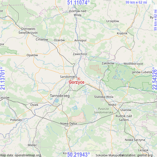
Gorzyce GPS coordinates[2]
50° 40' 1.92" North, 21° 50' 24.468" East
| Map corner | latitude | longitude |
|---|---|---|
| Upper-left | 51.11074°, | 21.13701° |
| Center: | 50.6672°, | 21.84013° |
| Lower-right: | 50.21943°, | 22.54326° |
| Map W x H: | 99.1×99.1 km | = 61.6×61.6mi |
| max Lat: | 54.83135° ⇑63.5% North |
| Gorzyce: | 50.6672° |
| min Lat: | ⇓36.5% South 49.21328° |
| min Long | Gorzyce | max Long |
| 14.20249° | 21.84013° | 24.03723° |
| W 82.6%⇐ | ⇒17.4% E |
Elevation
Elevation of Gorzyce is 141 m = 463 ft, and this is 50.4 m = 165 ft below average elevation for this country.
| Max E: |
974 m = 3196 ft | 62.4% |
| Avg. | 191.4 m = 628 ft | |
| Gorzyce | 141 m = 463 ft | |
Min E: |
-3 m = -10 ft | 37.6% |
See also: Poland elevation on elevation.city.
Geographical zone
Gorzyce is located in North temperate zone (between Tropic of Cancer and the Arctic Circle). Distance of this North polar circle is 1767.5 km =1098.3 mi to North.| Distance of | km | miles | from Gorzyce |
|---|---|---|---|
| North Pole | 4373.4 | 2717.5 | to North |
| Arctic Circle | 1767.5 | 1098.3 | to North |
| Tropic Cancer | 3027.7 | 1881.3 | to South |
| Equator | 5633.7 | 3500.6 | to South |


Nearby cities:
15 places around Gorzyce: (largest is in red/bold)
• Chwałowice
11.5 km =7.1 mi,  16°
16°
• Dwikozy
8.5 km =5.3 mi,  334°
334°
• Grębów
11.6 km =7.2 mi,  168°
168°
• Kępie Żaleszańskie
4.2 km =2.6 mi,  136°
136°
• Obrazów
13.7 km =8.5 mi,  282°
282°
• Radomyśl
7.5 km =4.7 mi,  78°
78°
• Samborzec
13.7 km =8.5 mi,  260°
260°
• Sandomierz
6.6 km =4.1 mi, 284°
• Sokolniki
4 km =2.5 mi,  216°
216°
• Tarnobrzeg
15.4 km =9.6 mi,  227°
227°
• Wilczyce
15.6 km =9.7 mi,  304°
304°
• Zaleszany
4.2 km =2.6 mi,  120°
120°
• Zawichost
15.6 km =9.7 mi,  3°
3°
• Złota
11.1 km =6.9 mi,  267°
267°
• Żabno
9.1 km =5.7 mi, 84°
Sources, notices
• [Note1] Compared only with cities in Poland existing in our database
• [Src1] Map data: © OpenStreetMap contributors (CC-BY-SA)
• [Src2] Other city data from geonames.org with taken over terms of usage.
• [Src3] Geographical zone / Annual Mean Temperature by Robert A. Rohde @ Wikipedia
