Joniec geodata
Joniec (Mazovia) is a seat of a third-order administrative division; located in Poland in Europe/Warsaw (GMT+2) time zone. With population of 270 people, there are 3632 cities with bigger population in this country. Compared to other cities in Poland, 77.9% of cities are located further ↓South; 66.1% of cities are located further ←West and 86.3% of cities have higher elevation than Joniec. Note1


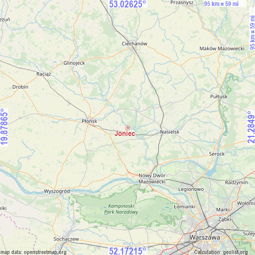
Joniec GPS coordinates[2]
52° 36' 4.608" North, 20° 34' 54.372" East
| Map corner | latitude | longitude |
|---|---|---|
| Upper-left | 53.02625°, | 19.87865° |
| Center: | 52.60128°, | 20.58177° |
| Lower-right: | 52.17215°, | 21.2849° |
| Map W x H: | 95×95 km | = 59×59mi |
| max Lat: | 54.83135° ⇑22.1% North |
| Joniec: | 52.60128° |
| min Lat: | ⇓77.9% South 49.21328° |
| min Long | Joniec | max Long |
| 14.20249° | 20.58177° | 24.03723° |
| W 66.1%⇐ | ⇒33.9% E |
Elevation
Elevation of Joniec is 86 m = 282 ft, and this is 105.4 m = 346 ft below average elevation for this country.
| Max E: |
974 m = 3196 ft | 86.3% |
| Avg. | 191.4 m = 628 ft | |
| Joniec | 86 m = 282 ft | |
Min E: |
-3 m = -10 ft | 13.7% |
See also: Poland elevation on elevation.city.
Geographical zone
Joniec is located in North temperate zone (between Tropic of Cancer and the Arctic Circle). Distance of this North polar circle is 1552.5 km =964.7 mi to North.| Distance of | km | miles | from Joniec |
|---|---|---|---|
| North Pole | 4158.3 | 2583.8 | to North |
| Arctic Circle | 1552.5 | 964.7 | to North |
| Tropic Cancer | 3242.8 | 2015 | to South |
| Equator | 5848.7 | 3634.2 | to South |


Nearby cities:
15 places around Joniec: (largest is in red/bold)
• Brody-Parcele
17.8 km =11.1 mi,  140°
140°
• Gołotczyzna
22.1 km =13.7 mi,  19°
19°
• Gąsocin
17.5 km =10.9 mi,  30°
30°
• Naruszewo
17.6 km =10.9 mi,  241°
241°
• Nasielsk
15.2 km =9.4 mi,  95°
95°
• Nowe Miasto
6.9 km =4.3 mi, 26°
• Nowy Dwór Mazowiecki
21.1 km =13.1 mi,  154°
154°
• Ojrzeń
18.5 km =11.5 mi,  351°
351°
• Pomiechówek
17.6 km =10.9 mi, 145°
• Płońsk
14.1 km =8.8 mi,  280°
280°
• Sochocin
12.1 km =7.5 mi,  322°
322°
• Sońsk
21.6 km =13.4 mi, 21°
• Zakroczym
18.8 km =11.7 mi,  173°
173°
• Załuski
10.6 km =6.6 mi,  199°
199°
• Świercze
14.5 km =9 mi,  57°
57°
Sources, notices
• [Note1] Compared only with cities in Poland existing in our database
• [Src1] Map data: © OpenStreetMap contributors (CC-BY-SA)
• [Src2] Other city data from geonames.org with taken over terms of usage.
• [Src3] Geographical zone / Annual Mean Temperature by Robert A. Rohde @ Wikipedia
