Słopnice geodata
Słopnice (Lesser Poland) is a populated place; located in Poland in Europe/Warsaw (GMT+2) time zone. With population of 4,601 people, there are 722 cities with bigger population in this country. Compared to other cities in Poland, 95% of cities are located further ↑North; 63.1% of cities are located further ←West and 96.8% of cities have lower elevation than Słopnice. Note1


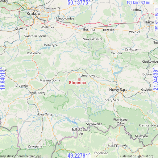
Słopnice GPS coordinates[2]
49° 41' 5.856" North, 20° 20' 35.7" East
| Map corner | latitude | longitude |
|---|---|---|
| Upper-left | 50.13775°, | 19.64013° |
| Center: | 49.68496°, | 20.34325° |
| Lower-right: | 49.22791°, | 21.04638° |
| Map W x H: | 101.2×101.2 km | = 62.9×62.9mi |
| max Lat: | 54.83135° ⇑95% North |
| Słopnice: | 49.68496° |
| min Lat: | ⇓5% South 49.21328° |
| min Long | Słopnice | max Long |
| 14.20249° | 20.34325° | 24.03723° |
| W 63.1%⇐ | ⇒36.9% E |
Elevation
Elevation of Słopnice is 465 m = 1526 ft, and this is 273.6 m = 898 ft above average elevation for this country.
| Max E: |
974 m = 3196 ft | 3.2% |
| Słopnice | 465 m 1526 ft | |
| Avg. | 191.4 m = 628 ft | |
Min E: |
-3 m = -10 ft | 96.8% |
See also: Poland elevation on elevation.city.
Geographical zone
Słopnice is located in North temperate zone (between Tropic of Cancer and the Arctic Circle). Distance of this North polar circle is 1876.7 km =1166.1 mi to North.| Distance of | km | miles | from Słopnice |
|---|---|---|---|
| North Pole | 4482.6 | 2785.4 | to North |
| Arctic Circle | 1876.7 | 1166.1 | to North |
| Tropic Cancer | 2918.5 | 1813.5 | to South |
| Equator | 5524.4 | 3432.7 | to South |


Nearby cities:
15 places around Słopnice: (largest is in red/bold)
• Dobra
7.4 km =4.6 mi,  299°
299°
• Jastrzębie
14.1 km =8.8 mi,  136°
136°
• Jodłownik
12.6 km =7.8 mi,  322°
322°
• Kamienica
12.2 km =7.6 mi,  179°
179°
• Laskowa
11.5 km =7.1 mi,  42°
42°
• Limanowa
6.1 km =3.8 mi,  67°
67°
• Lubomierz
13.2 km =8.2 mi,  230°
230°
• Skrzydlna
13.6 km =8.5 mi, 303°
• Tymbark
5 km =3.1 mi,  345°
345°
• Wilczyce
10.4 km =6.5 mi,  259°
259°
• Wysokie
14.8 km =9.2 mi,  103°
103°
• Zagorzyn
12.8 km =8 mi,  158°
158°
• Łukowica
13 km =8.1 mi,  129°
129°
• Łącko
15.7 km =9.8 mi,  154°
154°
• Żegocina
15.4 km =9.6 mi,  20°
20°
Sources, notices
• [Note1] Compared only with cities in Poland existing in our database
• [Src1] Map data: © OpenStreetMap contributors (CC-BY-SA)
• [Src2] Other city data from geonames.org with taken over terms of usage.
• [Src3] Geographical zone / Annual Mean Temperature by Robert A. Rohde @ Wikipedia
