Limanowa geodata
Limanowa (Lesser Poland) is a populated place; located in Poland in Europe/Warsaw (GMT+2) time zone. With population of 14,714 people, there are 344 cities with bigger population in this country. Compared to other cities in Poland, 94.5% of cities are located further ↑North; 64% of cities are located further ←West and 94.7% of cities have lower elevation than Limanowa. Note1


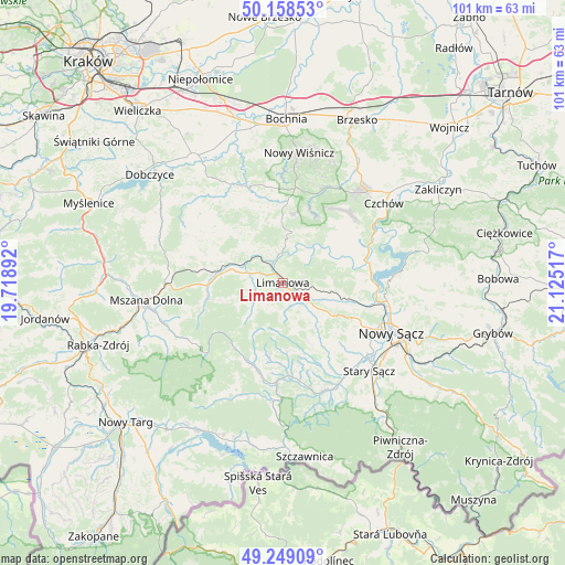
Limanowa GPS coordinates[2]
49° 42' 21.384" North, 20° 25' 19.344" East
| Map corner | latitude | longitude |
|---|---|---|
| Upper-left | 50.15853°, | 19.71892° |
| Center: | 49.70594°, | 20.42204° |
| Lower-right: | 49.24909°, | 21.12517° |
| Map W x H: | 101.1×101.1 km | = 62.8×62.8mi |
| max Lat: | 54.83135° ⇑94.5% North |
| Limanowa: | 49.70594° |
| min Lat: | ⇓5.5% South 49.21328° |
| min Long | Limanowa | max Long |
| 14.20249° | 20.42204° | 24.03723° |
| W 64%⇐ | ⇒36% E |
Elevation
Elevation of Limanowa is 408 m = 1339 ft, and this is 216.6 m = 711 ft above average elevation for this country.
| Max E: |
974 m = 3196 ft | 5.3% |
| Limanowa | 408 m 1339 ft | |
| Avg. | 191.4 m = 628 ft | |
Min E: |
-3 m = -10 ft | 94.7% |
See also: Poland elevation on elevation.city.
Geographical zone
Limanowa is located in North temperate zone (between Tropic of Cancer and the Arctic Circle). Distance of this North polar circle is 1874.4 km =1164.7 mi to North.| Distance of | km | miles | from Limanowa |
|---|---|---|---|
| North Pole | 4480.3 | 2783.9 | to North |
| Arctic Circle | 1874.4 | 1164.7 | to North |
| Tropic Cancer | 2920.9 | 1815 | to South |
| Equator | 5526.8 | 3434.2 | to South |


Nearby cities:
15 places around Limanowa: (largest is in red/bold)
• Dobra
12.2 km =7.6 mi,  276°
276°
• Jastrzębie
13.2 km =8.2 mi,  162°
162°
• Jodłownik
15.4 km =9.6 mi,  299°
299°
• Kamienica
15.5 km =9.6 mi,  200°
200°
• Laskowa
6.5 km =4 mi,  18°
18°
• Słopnice
6.1 km =3.8 mi,  247°
247°
• Trzciana
15.8 km =9.8 mi,  347°
347°
• Tymbark
7.4 km =4.6 mi,  289°
289°
• Wilczyce
16.5 km =10.3 mi, 254°
• Wysokie
10.5 km =6.5 mi,  123°
123°
• Zagorzyn
14.3 km =8.9 mi,  184°
184°
• Łososina Dolna
15.8 km =9.8 mi,  72°
72°
• Łukowica
11.4 km =7.1 mi, 157°
• Łącko
16.5 km =10.3 mi, 176°
• Żegocina
12 km =7.5 mi,  359°
359°
Sources, notices
• [Note1] Compared only with cities in Poland existing in our database
• [Src1] Map data: © OpenStreetMap contributors (CC-BY-SA)
• [Src2] Other city data from geonames.org with taken over terms of usage.
• [Src3] Geographical zone / Annual Mean Temperature by Robert A. Rohde @ Wikipedia
