Rudka geodata
Rudka (Podlasie) is a populated place; located in Poland in Europe/Warsaw (GMT+2) time zone. With population of 1,400 people, there are 1959 cities with bigger population in this country. Compared to other cities in Poland, 79.6% of cities are located further ↓South; 94% of cities are located further ←West and 64.1% of cities have higher elevation than Rudka. Note1


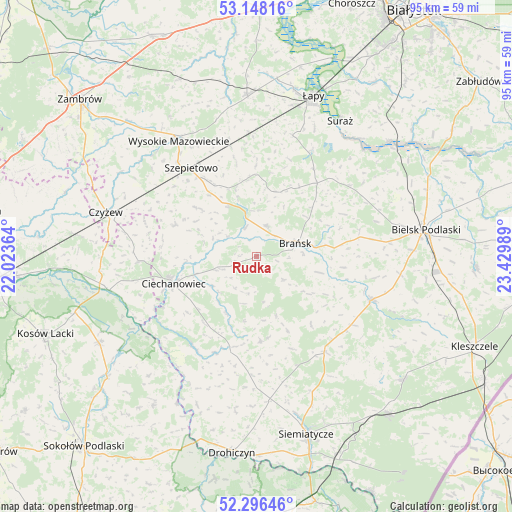
Rudka GPS coordinates[2]
52° 43' 27.804" North, 22° 43' 36.336" East
| Map corner | latitude | longitude |
|---|---|---|
| Upper-left | 53.14816°, | 22.02364° |
| Center: | 52.72439°, | 22.72676° |
| Lower-right: | 52.29646°, | 23.42989° |
| Map W x H: | 94.7×94.7 km | = 58.8×58.8mi |
| max Lat: | 54.83135° ⇑20.4% North |
| Rudka: | 52.72439° |
| min Lat: | ⇓79.6% South 49.21328° |
| min Long | Rudka | max Long |
| 14.20249° | 22.72676° | 24.03723° |
| W 94%⇐ | ⇒6% E |
Elevation
Elevation of Rudka is 136 m = 446 ft, and this is 55.4 m = 182 ft below average elevation for this country.
| Max E: |
974 m = 3196 ft | 64.1% |
| Avg. | 191.4 m = 628 ft | |
| Rudka | 136 m = 446 ft | |
Min E: |
-3 m = -10 ft | 35.9% |
See also: Poland elevation on elevation.city.
Geographical zone
Rudka is located in North temperate zone (between Tropic of Cancer and the Arctic Circle). Distance of this North polar circle is 1538.8 km =956.2 mi to North.| Distance of | km | miles | from Rudka |
|---|---|---|---|
| North Pole | 4144.7 | 2575.4 | to North |
| Arctic Circle | 1538.8 | 956.2 | to North |
| Tropic Cancer | 3256.5 | 2023.5 | to South |
| Equator | 5862.4 | 3642.7 | to South |


Nearby cities:
15 places around Rudka: (largest is in red/bold)
• Boguty-Pianki
21 km =13 mi,  267°
267°
• Boćki
22.9 km =14.2 mi,  110°
110°
• Brańsk
7.8 km =4.8 mi,  73°
73°
• Ciechanowiec
16.2 km =10.1 mi,  251°
251°
• Czyżew
29 km =18 mi,  286°
286°
• Dziadkowice
22 km =13.7 mi,  144°
144°
• Grodzisk
15.6 km =9.7 mi,  177°
177°
• Klukowo
15.9 km =9.9 mi, 291°
• Nur
28 km =17.4 mi,  257°
257°
• Perlejewo
20.7 km =12.9 mi,  211°
211°
• Sokoły
29.9 km =18.6 mi,  356°
356°
• Suraż
29.4 km =18.3 mi,  31°
31°
• Szepietowo
20.4 km =12.7 mi,  322°
322°
• Wysokie Mazowieckie
25.6 km =15.9 mi,  326°
326°
• Wyszki
21.5 km =13.4 mi,  52°
52°
Sources, notices
• [Note1] Compared only with cities in Poland existing in our database
• [Src1] Map data: © OpenStreetMap contributors (CC-BY-SA)
• [Src2] Other city data from geonames.org with taken over terms of usage.
• [Src3] Geographical zone / Annual Mean Temperature by Robert A. Rohde @ Wikipedia
