Wola Rębkowska geodata
Wola Rębkowska (Mazovia) is a populated place; located in Poland in Europe/Warsaw (GMT+2) time zone. With population of 1,400 people, there are 1959 cities with bigger population in this country. Compared to other cities in Poland, 63.7% of cities are located further ↓South; 79.7% of cities are located further ←West and 67.1% of cities have higher elevation than Wola Rębkowska. Note1


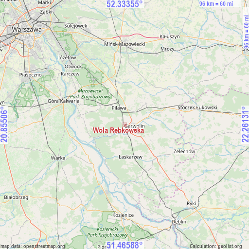
Wola Rębkowska GPS coordinates[2]
51° 54' 6.516" North, 21° 33' 29.448" East
| Map corner | latitude | longitude |
|---|---|---|
| Upper-left | 52.33355°, | 20.85506° |
| Center: | 51.90181°, | 21.55818° |
| Lower-right: | 51.46588°, | 22.26131° |
| Map W x H: | 96.5×96.5 km | = 60×60mi |
| max Lat: | 54.83135° ⇑36.3% North |
| Wola Rębkowska: | 51.90181° |
| min Lat: | ⇓63.7% South 49.21328° |
| min Long | Wola Rębkowska | max Long |
| 14.20249° | 21.55818° | 24.03723° |
| W 79.7%⇐ | ⇒20.3% E |
Elevation
Elevation of Wola Rębkowska is 128 m = 420 ft, and this is 63.4 m = 208 ft below average elevation for this country.
| Max E: |
974 m = 3196 ft | 67.1% |
| Avg. | 191.4 m = 628 ft | |
| Wola Rębkowska | 128 m = 420 ft | |
Min E: |
-3 m = -10 ft | 32.9% |
See also: Poland elevation on elevation.city.
Geographical zone
Wola Rębkowska is located in North temperate zone (between Tropic of Cancer and the Arctic Circle). Distance of this North polar circle is 1630.2 km =1013 mi to North.| Distance of | km | miles | from Wola Rębkowska |
|---|---|---|---|
| North Pole | 4236.1 | 2632.2 | to North |
| Arctic Circle | 1630.2 | 1013 | to North |
| Tropic Cancer | 3165 | 1966.6 | to South |
| Equator | 5770.9 | 3585.9 | to South |


Nearby cities:
15 places around Wola Rębkowska: (largest is in red/bold)
• Borowie
15.2 km =9.4 mi,  69°
69°
• Garwolin
3.9 km =2.4 mi,  97°
97°
• Górzno
12 km =7.5 mi,  120°
120°
• Miastków Kościelny
18.4 km =11.4 mi, 96°
• Miętne
2.4 km =1.5 mi,  27°
27°
• Osieck
11.9 km =7.4 mi,  307°
307°
• Parysów
11.7 km =7.3 mi,  45°
45°
• Pilawa
6.7 km =4.2 mi,  343°
343°
• Rębków
2.9 km =1.8 mi,  186°
186°
• Sobienie Jeziory
17.8 km =11.1 mi,  281°
281°
• Sulbiny Górne
6 km =3.7 mi, 122°
• Trąbki
5.9 km =3.7 mi, 28°
• Wielgolas
18.7 km =11.6 mi,  39°
39°
• Wilga
13.6 km =8.5 mi,  245°
245°
• Łaskarzew
12.6 km =7.8 mi,  169°
169°
Sources, notices
• [Note1] Compared only with cities in Poland existing in our database
• [Src1] Map data: © OpenStreetMap contributors (CC-BY-SA)
• [Src2] Other city data from geonames.org with taken over terms of usage.
• [Src3] Geographical zone / Annual Mean Temperature by Robert A. Rohde @ Wikipedia
