Łaskarzew geodata
Łaskarzew (Mazovia) is a seat of a third-order administrative division; located in Poland in Europe/Warsaw (GMT+2) time zone. With population of 4,893 people, there are 699 cities with bigger population in this country. Compared to other cities in Poland, 61.9% of cities are located further ↓South; 80.1% of cities are located further ←West and 65.6% of cities have higher elevation than Łaskarzew. Note1


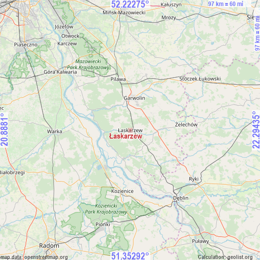
Łaskarzew GPS coordinates[2]
51° 47' 23.748" North, 21° 35' 28.392" East
| Map corner | latitude | longitude |
|---|---|---|
| Upper-left | 52.22275°, | 20.8881° |
| Center: | 51.78993°, | 21.59122° |
| Lower-right: | 51.35292°, | 22.29435° |
| Map W x H: | 96.7×96.7 km | = 60.1×60.1mi |
| max Lat: | 54.83135° ⇑38.1% North |
| Łaskarzew: | 51.78993° |
| min Lat: | ⇓61.9% South 49.21328° |
| min Long | Łaskarzew | max Long |
| 14.20249° | 21.59122° | 24.03723° |
| W 80.1%⇐ | ⇒19.9% E |
Elevation
Elevation of Łaskarzew is 131 m = 430 ft, and this is 60.4 m = 198 ft below average elevation for this country.
| Max E: |
974 m = 3196 ft | 65.6% |
| Avg. | 191.4 m = 628 ft | |
| Łaskarzew | 131 m = 430 ft | |
Min E: |
-3 m = -10 ft | 34.4% |
See also: Poland elevation on elevation.city.
Geographical zone
Łaskarzew is located in North temperate zone (between Tropic of Cancer and the Arctic Circle). Distance of this North polar circle is 1642.7 km =1020.7 mi to North.| Distance of | km | miles | from Łaskarzew |
|---|---|---|---|
| North Pole | 4248.6 | 2640 | to North |
| Arctic Circle | 1642.7 | 1020.7 | to North |
| Tropic Cancer | 3152.6 | 1958.9 | to South |
| Equator | 5758.5 | 3578.2 | to South |


Nearby cities:
15 places around Łaskarzew: (largest is in red/bold)
• Garwolin
12.1 km =7.5 mi,  7°
7°
• Górzno
10.3 km =6.4 mi,  52°
52°
• Kobylnica
16.1 km =10 mi,  183°
183°
• Maciejowice
11.2 km =7 mi,  193°
193°
• Magnuszew
14.8 km =9.2 mi,  259°
259°
• Miętne
14.7 km =9.1 mi,  355°
355°
• Paprotnia
18.3 km =11.4 mi,  164°
164°
• Ryczywół
16 km =9.9 mi,  226°
226°
• Rębków
9.9 km =6.2 mi,  344°
344°
• Sobolew
7.7 km =4.8 mi,  140°
140°
• Sulbiny Górne
9.7 km =6 mi,  16°
16°
• Trojanów
18.6 km =11.6 mi,  125°
125°
• Trąbki
17.6 km =10.9 mi,  1°
1°
• Wilga
16.2 km =10.1 mi,  295°
295°
• Wola Rębkowska
12.6 km =7.8 mi,  349°
349°
Sources, notices
• [Note1] Compared only with cities in Poland existing in our database
• [Src1] Map data: © OpenStreetMap contributors (CC-BY-SA)
• [Src2] Other city data from geonames.org with taken over terms of usage.
• [Src3] Geographical zone / Annual Mean Temperature by Robert A. Rohde @ Wikipedia
