Borowie geodata
Borowie (Mazovia) is a seat of a third-order administrative division; located in Poland in Europe/Warsaw (GMT+2) time zone. With population of 400 people, there are 3589 cities with bigger population in this country. Compared to other cities in Poland, 64.6% of cities are located further ↓South; 82% of cities are located further ←West and 57.6% of cities have higher elevation than Borowie. Note1


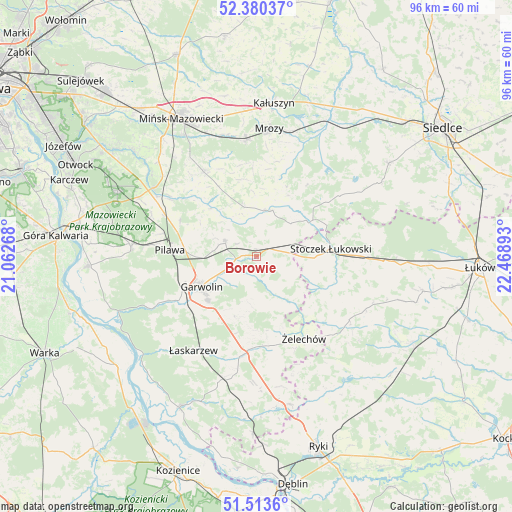
Borowie GPS coordinates[2]
51° 56' 56.688" North, 21° 45' 56.88" East
| Map corner | latitude | longitude |
|---|---|---|
| Upper-left | 52.38037°, | 21.06268° |
| Center: | 51.94908°, | 21.7658° |
| Lower-right: | 51.5136°, | 22.46893° |
| Map W x H: | 96.4×96.4 km | = 59.9×59.9mi |
| max Lat: | 54.83135° ⇑35.4% North |
| Borowie: | 51.94908° |
| min Lat: | ⇓64.6% South 49.21328° |
| min Long | Borowie | max Long |
| 14.20249° | 21.7658° | 24.03723° |
| W 82%⇐ | ⇒18% E |
Elevation
Elevation of Borowie is 152 m = 499 ft, and this is 39.4 m = 129 ft below average elevation for this country.
| Max E: |
974 m = 3196 ft | 57.6% |
| Avg. | 191.4 m = 628 ft | |
| Borowie | 152 m = 499 ft | |
Min E: |
-3 m = -10 ft | 42.4% |
See also: Poland elevation on elevation.city.
Geographical zone
Borowie is located in North temperate zone (between Tropic of Cancer and the Arctic Circle). Distance of this North polar circle is 1625 km =1009.7 mi to North.| Distance of | km | miles | from Borowie |
|---|---|---|---|
| North Pole | 4230.9 | 2629 | to North |
| Arctic Circle | 1625 | 1009.7 | to North |
| Tropic Cancer | 3170.3 | 1969.9 | to South |
| Equator | 5776.2 | 3589.2 | to South |


Nearby cities:
15 places around Borowie: (largest is in red/bold)
• Garwolin
11.8 km =7.3 mi,  241°
241°
• Górzno
12 km =7.5 mi,  198°
198°
• Latowicz
9.1 km =5.7 mi,  18°
18°
• Miastków Kościelny
8.3 km =5.2 mi,  150°
150°
• Miętne
13.5 km =8.4 mi,  256°
256°
• Parysów
6.6 km =4.1 mi,  296°
296°
• Pilawa
16.1 km =10 mi,  274°
274°
• Rębków
16.7 km =10.4 mi, 240°
• Stoczek Łukowski
14.2 km =8.8 mi,  84°
84°
• Sulbiny Górne
12.5 km =7.8 mi,  227°
227°
• Trąbki
11.4 km =7.1 mi, 269°
• Wielgolas
9.5 km =5.9 mi,  346°
346°
• Wodynie
16.5 km =10.3 mi,  52°
52°
• Wola Rębkowska
15.2 km =9.4 mi,  249°
249°
• Żelechów
17.9 km =11.1 mi, 149°
Sources, notices
• [Note1] Compared only with cities in Poland existing in our database
• [Src1] Map data: © OpenStreetMap contributors (CC-BY-SA)
• [Src2] Other city data from geonames.org with taken over terms of usage.
• [Src3] Geographical zone / Annual Mean Temperature by Robert A. Rohde @ Wikipedia
