Wilga geodata
Wilga (Mazovia) is a seat of a third-order administrative division; located in Poland in Europe/Warsaw (GMT+2) time zone. With population of 1,000 people, there are 2459 cities with bigger population in this country. Compared to other cities in Poland, 62.7% of cities are located further ↓South; 77.8% of cities are located further ←West and 80.6% of cities have higher elevation than Wilga. Note1


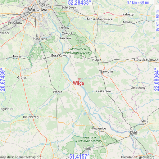
Wilga GPS coordinates[2]
51° 51' 7.596" North, 21° 22' 39.036" East
| Map corner | latitude | longitude |
|---|---|---|
| Upper-left | 52.28433°, | 20.67439° |
| Center: | 51.85211°, | 21.37751° |
| Lower-right: | 51.4157°, | 22.08064° |
| Map W x H: | 96.6×96.6 km | = 60×60mi |
| max Lat: | 54.83135° ⇑37.3% North |
| Wilga: | 51.85211° |
| min Lat: | ⇓62.7% South 49.21328° |
| min Long | Wilga | max Long |
| 14.20249° | 21.37751° | 24.03723° |
| W 77.8%⇐ | ⇒22.2% E |
Elevation
Elevation of Wilga is 98 m = 322 ft, and this is 93.4 m = 306 ft below average elevation for this country.
| Max E: |
974 m = 3196 ft | 80.6% |
| Avg. | 191.4 m = 628 ft | |
| Wilga | 98 m = 322 ft | |
Min E: |
-3 m = -10 ft | 19.4% |
See also: Poland elevation on elevation.city.
Geographical zone
Wilga is located in North temperate zone (between Tropic of Cancer and the Arctic Circle). Distance of this North polar circle is 1635.8 km =1016.4 mi to North.| Distance of | km | miles | from Wilga |
|---|---|---|---|
| North Pole | 4241.6 | 2635.6 | to North |
| Arctic Circle | 1635.8 | 1016.4 | to North |
| Tropic Cancer | 3159.5 | 1963.2 | to South |
| Equator | 5765.4 | 3582.5 | to South |


Nearby cities:
15 places around Wilga: (largest is in red/bold)
• Czersk
15.5 km =9.6 mi,  319°
319°
• Garwolin
17 km =10.6 mi,  72°
72°
• Góra Kalwaria
17.7 km =11 mi, 321°
• Magnuszew
9.7 km =6 mi,  179°
179°
• Miętne
15.6 km =9.7 mi,  60°
60°
• Osieck
13 km =8.1 mi,  12°
12°
• Pilawa
15.9 km =9.9 mi,  41°
41°
• Ryczywół
18.2 km =11.3 mi,  170°
170°
• Rębków
12.4 km =7.7 mi,  77°
77°
• Sobienie Jeziory
10.3 km =6.4 mi,  330°
330°
• Sulbiny Górne
17.6 km =10.9 mi, 82°
• Trąbki
18.6 km =11.6 mi, 55°
• Warka
14.9 km =9.3 mi,  239°
239°
• Wola Rębkowska
13.6 km =8.5 mi, 65°
• Łaskarzew
16.2 km =10.1 mi,  115°
115°
Sources, notices
• [Note1] Compared only with cities in Poland existing in our database
• [Src1] Map data: © OpenStreetMap contributors (CC-BY-SA)
• [Src2] Other city data from geonames.org with taken over terms of usage.
• [Src3] Geographical zone / Annual Mean Temperature by Robert A. Rohde @ Wikipedia
