Miastków Kościelny geodata
Miastków Kościelny (Mazovia) is a seat of a third-order administrative division; located in Poland in Europe/Warsaw (GMT+2) time zone. With population of 630 people, there are 3202 cities with bigger population in this country. Compared to other cities in Poland, 63.3% of cities are located further ↓South; 82.5% of cities are located further ←West and 54.5% of cities have higher elevation than Miastków Kościelny. Note1
Administrative division(s):
- Level 1: Mazovia
- Level 2: Powiat garwoliński
- Level 3: Miastków Kościelny


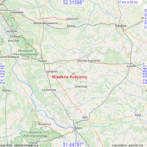
Miastków Kościelny GPS coordinates[2]
51° 53' 2.652" North, 21° 49' 31.008" East
| Map corner | latitude | longitude |
|---|---|---|
| Upper-left | 52.31598°, | 21.12216° |
| Center: | 51.88407°, | 21.82528° |
| Lower-right: | 51.44797°, | 22.52841° |
| Map W x H: | 96.5×96.5 km | = 60×60mi |
| max Lat: | 54.83135° ⇑36.7% North |
| Miastków Kościelny: | 51.88407° |
| min Lat: | ⇓63.3% South 49.21328° |
| min Long | Miastków Kośc | max Long |
| 14.20249° | 21.82528° | 24.03723° |
| W 82.5%⇐ | ⇒17.5% E |
Elevation
Elevation of Miastków Kościelny is 160 m = 525 ft, and this is 31.4 m = 103 ft below average elevation for this country.
| Max E: |
974 m = 3196 ft | 54.5% |
| Avg. | 191.4 m = 628 ft | |
| Miastków Kościelny | 160 m = 525 ft | |
Min E: |
-3 m = -10 ft | 45.5% |
See also: Poland elevation on elevation.city.
Geographical zone
Miastków Kościelny is located in North temperate zone (between Tropic of Cancer and the Arctic Circle). Distance of this North polar circle is 1632.2 km =1014.2 mi to North.| Distance of | km | miles | from Miastków Kościelny |
|---|---|---|---|
| North Pole | 4238.1 | 2633.4 | to North |
| Arctic Circle | 1632.2 | 1014.2 | to North |
| Tropic Cancer | 3163 | 1965.4 | to South |
| Equator | 5769 | 3584.7 | to South |


Nearby cities:
15 places around Miastków Kościelny: (largest is in red/bold)
• Borowie
8.3 km =5.2 mi,  330°
330°
• Garwolin
14.5 km =9 mi,  275°
275°
• Górzno
9 km =5.6 mi,  242°
242°
• Latowicz
15.9 km =9.9 mi,  355°
355°
• Miętne
17.7 km =11 mi, 283°
• Parysów
14.3 km =8.9 mi,  315°
315°
• Rębków
18.7 km =11.6 mi,  267°
267°
• Stoczek Łukowski
13.2 km =8.2 mi,  49°
49°
• Sulbiny Górne
13.3 km =8.3 mi,  264°
264°
• Trąbki
17 km =10.6 mi,  294°
294°
• Wielgolas
17.6 km =10.9 mi,  338°
338°
• Wodynie
19.5 km =12.1 mi,  27°
27°
• Wola Rębkowska
18.4 km =11.4 mi, 276°
• Łaskarzew
19.2 km =11.9 mi, 236°
• Żelechów
9.6 km =6 mi,  148°
148°
Sources, notices
• [Note1] Compared only with cities in Poland existing in our database
• [Src1] Map data: © OpenStreetMap contributors (CC-BY-SA)
• [Src2] Other city data from geonames.org with taken over terms of usage.
• [Src3] Geographical zone / Annual Mean Temperature by Robert A. Rohde @ Wikipedia
