Paprotnia geodata
Paprotnia (Mazovia) is a populated place; located in Poland in Europe/Warsaw (GMT+2) time zone. With population of 1,539 people, there are 1815 cities with bigger population in this country. Compared to other cities in Poland, 70.3% of cities are located further ↓South; 64% of cities are located further ←West and 85.2% of cities have higher elevation than Paprotnia. Note1


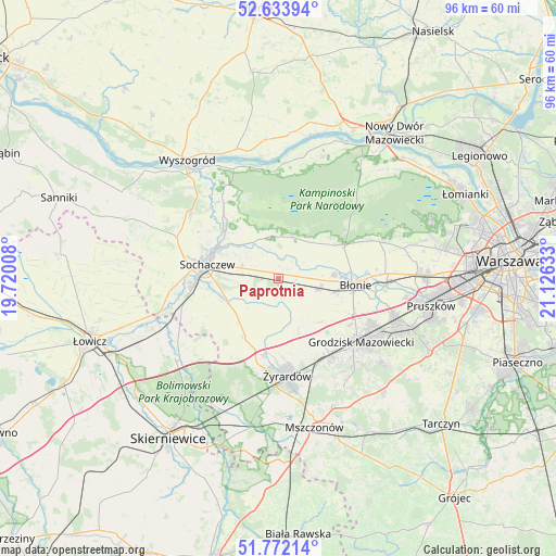
Paprotnia GPS coordinates[2]
52° 12' 18.468" North, 20° 25' 23.52" East
| Map corner | latitude | longitude |
|---|---|---|
| Upper-left | 52.63394°, | 19.72008° |
| Center: | 52.20513°, | 20.4232° |
| Lower-right: | 51.77214°, | 21.12633° |
| Map W x H: | 95.8×95.8 km | = 59.5×59.5mi |
| max Lat: | 54.83135° ⇑29.7% North |
| Paprotnia: | 52.20513° |
| min Lat: | ⇓70.3% South 49.21328° |
| min Long | Paprotnia | max Long |
| 14.20249° | 20.4232° | 24.03723° |
| W 64%⇐ | ⇒36% E |
Elevation
Elevation of Paprotnia is 89 m = 292 ft, and this is 102.4 m = 336 ft below average elevation for this country.
| Max E: |
974 m = 3196 ft | 85.2% |
| Avg. | 191.4 m = 628 ft | |
| Paprotnia | 89 m = 292 ft | |
Min E: |
-3 m = -10 ft | 14.8% |
See also: Poland elevation on elevation.city.
Geographical zone
Paprotnia is located in North temperate zone (between Tropic of Cancer and the Arctic Circle). Distance of this North polar circle is 1596.5 km =992 mi to North.| Distance of | km | miles | from Paprotnia |
|---|---|---|---|
| North Pole | 4202.4 | 2611.2 | to North |
| Arctic Circle | 1596.5 | 992 | to North |
| Tropic Cancer | 3198.7 | 1987.6 | to South |
| Equator | 5804.7 | 3606.9 | to South |


Nearby cities:
15 places around Paprotnia: (largest is in red/bold)
• Bieniewice
9.9 km =6.2 mi,  104°
104°
• Boża Wola
7.2 km =4.5 mi,  106°
106°
• Brochów
16.8 km =10.4 mi,  319°
319°
• Błonie
13.2 km =8.2 mi,  93°
93°
• Czerwonka-Parcel
10.9 km =6.8 mi,  276°
276°
• Guzów
11.5 km =7.1 mi,  210°
210°
• Jaktorów
16.4 km =10.2 mi,  149°
149°
• Kampinos
7.5 km =4.7 mi,  21°
21°
• Kozłów Biskupi
15.8 km =9.8 mi,  264°
264°
• Leszno
12.9 km =8 mi,  62°
62°
• Miedniewice
15.9 km =9.9 mi, 211°
• Sochaczew
12.9 km =8 mi, 282°
• Teresin
0.8 km =0.5 mi, 212°
• Wiskitki
13.2 km =8.2 mi,  190°
190°
• Żyrardów
17.5 km =10.9 mi,  174°
174°
Sources, notices
• [Note1] Compared only with cities in Poland existing in our database
• [Src1] Map data: © OpenStreetMap contributors (CC-BY-SA)
• [Src2] Other city data from geonames.org with taken over terms of usage.
• [Src3] Geographical zone / Annual Mean Temperature by Robert A. Rohde @ Wikipedia
