Wokowice geodata
Wokowice (Lesser Poland) is a populated place; located in Poland in Europe/Warsaw (GMT+2) time zone. With population of 513 people, there are 3508 cities with bigger population in this country. Compared to other cities in Poland, 82.2% of cities are located further ↑North; 67.7% of cities are located further ←West and 61% of cities have lower elevation than Wokowice. Note1


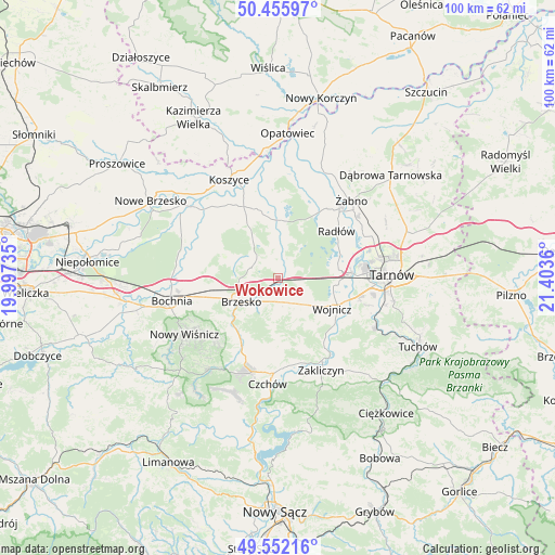
Wokowice GPS coordinates[2]
50° 0' 22.284" North, 20° 42' 1.692" East
| Map corner | latitude | longitude |
|---|---|---|
| Upper-left | 50.45597°, | 19.99735° |
| Center: | 50.00619°, | 20.70047° |
| Lower-right: | 49.55216°, | 21.4036° |
| Map W x H: | 100.5×100.5 km | = 62.4×62.4mi |
| max Lat: | 54.83135° ⇑82.2% North |
| Wokowice: | 50.00619° |
| min Lat: | ⇓17.8% South 49.21328° |
| min Long | Wokowice | max Long |
| 14.20249° | 20.70047° | 24.03723° |
| W 67.7%⇐ | ⇒32.3% E |
Elevation
Elevation of Wokowice is 203 m = 666 ft, and this is 11.6 m = 38 ft above average elevation for this country.
| Max E: |
974 m = 3196 ft | 39% |
| Wokowice | 203 m 666 ft | |
| Avg. | 191.4 m = 628 ft | |
Min E: |
-3 m = -10 ft | 61% |
See also: Poland elevation on elevation.city.
Geographical zone
Wokowice is located in North temperate zone (between Tropic of Cancer and the Arctic Circle). Distance of this North polar circle is 1841 km =1143.9 mi to North.| Distance of | km | miles | from Wokowice |
|---|---|---|---|
| North Pole | 4446.9 | 2763.2 | to North |
| Arctic Circle | 1841 | 1143.9 | to North |
| Tropic Cancer | 2954.2 | 1835.7 | to South |
| Equator | 5560.2 | 3454.9 | to South |


Nearby cities:
15 places around Wokowice: (largest is in red/bold)
• Borzęcin
6.6 km =4.1 mi,  6°
6°
• Brzesko
7.9 km =4.9 mi,  238°
238°
• Dębno
4.6 km =2.9 mi,  162°
162°
• Jadowniki
6.6 km =4.1 mi,  217°
217°
• Jasień
10 km =6.2 mi,  246°
246°
• Jodłówka
11 km =6.8 mi,  262°
262°
• Maszkienice
2.1 km =1.3 mi,  207°
207°
• Okocim
9.5 km =5.9 mi,  227°
227°
• Porąbka Uszewska
7.1 km =4.4 mi,  185°
185°
• Przyborów
3.8 km =2.4 mi,  314°
314°
• Rudy-Rysie
7.6 km =4.7 mi,  323°
323°
• Sterkowiec
1.9 km =1.2 mi, 228°
• Szczepanów
3.3 km =2.1 mi,  268°
268°
• Wola Dębińska
2.8 km =1.7 mi,  198°
198°
• Łoniowa
10 km =6.2 mi,  182°
182°
Sources, notices
• [Note1] Compared only with cities in Poland existing in our database
• [Src1] Map data: © OpenStreetMap contributors (CC-BY-SA)
• [Src2] Other city data from geonames.org with taken over terms of usage.
• [Src3] Geographical zone / Annual Mean Temperature by Robert A. Rohde @ Wikipedia
