Tarnów geodata
Tarnów (Lesser Poland) is a seat of a second-order administrative division; located in Poland in Europe/Warsaw (GMT+2) time zone. With population of 117,799 people, there are 41 cities with bigger population in this country. Compared to other cities in Poland, 81.8% of cities are located further ↑North; 72.4% of cities are located further ←West and 67.1% of cities have lower elevation than Tarnów. Note1


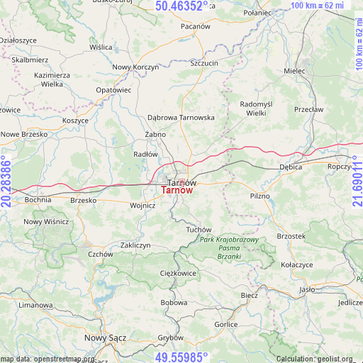
Tarnów GPS coordinates[2]
50° 0' 49.716" North, 20° 59' 13.128" East
| Map corner | latitude | longitude |
|---|---|---|
| Upper-left | 50.46352°, | 20.28386° |
| Center: | 50.01381°, | 20.98698° |
| Lower-right: | 49.55985°, | 21.69011° |
| Map W x H: | 100.5×100.5 km | = 62.4×62.4mi |
| max Lat: | 54.83135° ⇑81.8% North |
| Tarnów: | 50.01381° |
| min Lat: | ⇓18.2% South 49.21328° |
| min Long | Tarnów | max Long |
| 14.20249° | 20.98698° | 24.03723° |
| W 72.4%⇐ | ⇒27.6% E |
Elevation
Elevation of Tarnów is 220 m = 722 ft, and this is 28.6 m = 94 ft above average elevation for this country.
| Max E: |
974 m = 3196 ft | 32.9% |
| Tarnów | 220 m 722 ft | |
| Avg. | 191.4 m = 628 ft | |
Min E: |
-3 m = -10 ft | 67.1% |
See also: Tarnów elevation on elevation.city.
Geographical zone
Tarnów is located in North temperate zone (between Tropic of Cancer and the Arctic Circle). Distance of this North polar circle is 1840.2 km =1143.4 mi to North.| Distance of | km | miles | from Tarnów |
|---|---|---|---|
| North Pole | 4446 | 2762.6 | to North |
| Arctic Circle | 1840.2 | 1143.4 | to North |
| Tropic Cancer | 2955.1 | 1836.2 | to South |
| Equator | 5561 | 3455.4 | to South |


Nearby cities:
15 places around Tarnów: (largest is in red/bold)
• Bogumiłowice
8.6 km =5.3 mi,  265°
265°
• Błonie
9.1 km =5.7 mi,  221°
221°
• Jodłówka-Wałki
11.2 km =7 mi,  68°
68°
• Karwodrza
11.5 km =7.1 mi,  147°
147°
• Koszyce
5.6 km =3.5 mi, 215°
• Koszyce Wielkie
4.7 km =2.9 mi, 218°
• Lisia Góra
8.4 km =5.2 mi,  28°
28°
• Pleśna
10.2 km =6.3 mi,  197°
197°
• Pogórska Wola
12.2 km =7.6 mi,  87°
87°
• Skrzyszów
5.8 km =3.6 mi,  112°
112°
• Szynwałd
11 km =6.8 mi,  117°
117°
• Tarnowiec
3.6 km =2.2 mi,  180°
180°
• Wierzchosławice
9.4 km =5.8 mi,  277°
277°
• Wojnicz
12.3 km =7.6 mi,  239°
239°
• Łukowa
8.8 km =5.5 mi,  354°
354°
Sources, notices
• [Note1] Compared only with cities in Poland existing in our database
• [Src1] Map data: © OpenStreetMap contributors (CC-BY-SA)
• [Src2] Other city data from geonames.org with taken over terms of usage.
• [Src3] Geographical zone / Annual Mean Temperature by Robert A. Rohde @ Wikipedia
