Hrubieszów geodata
Hrubieszów (Lublin) is a seat of a third-order administrative division; located in Poland in Europe/Warsaw (GMT+2) time zone. With population of 18,605 people, there are 262 cities with bigger population in this country. Compared to other cities in Poland, 60% of cities are located further ↑North; 99.9% of cities are located further ←West and 56% of cities have lower elevation than Hrubieszów. Note1


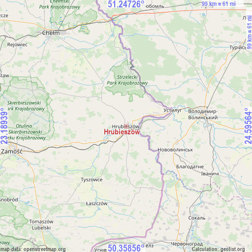
Hrubieszów GPS coordinates[2]
50° 48' 18.072" North, 23° 53' 33.036" East
| Map corner | latitude | longitude |
|---|---|---|
| Upper-left | 51.24726°, | 23.18939° |
| Center: | 50.80502°, | 23.89251° |
| Lower-right: | 50.35856°, | 24.59564° |
| Map W x H: | 98.8×98.8 km | = 61.4×61.4mi |
| max Lat: | 54.83135° ⇑60% North |
| Hrubieszów: | 50.80502° |
| min Lat: | ⇓40% South 49.21328° |
| min Long | Hrubieszów | max Long |
| 14.20249° | 23.89251° | 24.03723° |
| W 99.9%⇐ | ⇒0.099999999999994% E |
Elevation
Elevation of Hrubieszów is 188 m = 617 ft, and this is 3.4 m = 11 ft below average elevation for this country.
| Max E: |
974 m = 3196 ft | 44% |
| Avg. | 191.4 m = 628 ft | |
| Hrubieszów | 188 m = 617 ft | |
Min E: |
-3 m = -10 ft | 56% |
See also: Poland elevation on elevation.city.
Geographical zone
Hrubieszów is located in North temperate zone (between Tropic of Cancer and the Arctic Circle). Distance of this North polar circle is 1752.2 km =1088.8 mi to North.| Distance of | km | miles | from Hrubieszów |
|---|---|---|---|
| North Pole | 4358.1 | 2708 | to North |
| Arctic Circle | 1752.2 | 1088.8 | to North |
| Tropic Cancer | 3043.1 | 1890.9 | to South |
| Equator | 5649 | 3510.1 | to South |


Nearby cities:
15 places around Hrubieszów: (largest is in red/bold)
• Białopole
23.1 km =14.4 mi,  330°
330°
• Dołhobyczów
26.4 km =16.4 mi,  157°
157°
• Dubienka
27.1 km =16.8 mi,  0°
0°
• Grabowiec
24.1 km =15 mi,  274°
274°
• Horodło
14.2 km =8.8 mi,  45°
45°
• Hrebenne
11.4 km =7.1 mi, 48°
• Jarosławiec
17.7 km =11 mi,  310°
310°
• Mircze
17.1 km =10.6 mi,  179°
179°
• Miączyn
28.5 km =17.7 mi,  254°
254°
• Trzeszczany
11.1 km =6.9 mi,  279°
279°
• Tyszowce
24.9 km =15.5 mi,  213°
213°
• Uchanie
20.5 km =12.7 mi,  304°
304°
• Werbkowice
10.7 km =6.6 mi,  237°
237°
• Wojsławice
27.4 km =17 mi, 297°
• Żmudź
28.2 km =17.5 mi, 327°
Sources, notices
• [Note1] Compared only with cities in Poland existing in our database
• [Src1] Map data: © OpenStreetMap contributors (CC-BY-SA)
• [Src2] Other city data from geonames.org with taken over terms of usage.
• [Src3] Geographical zone / Annual Mean Temperature by Robert A. Rohde @ Wikipedia
