Hrebenne geodata
Hrebenne (Lublin) is a populated place; located in Poland in Europe/Warsaw (GMT+2) time zone. With population of 501 people, there are 3539 cities with bigger population in this country. Compared to other cities in Poland, 58.5% of cities are located further ↑North; 99.9% of cities are located further ←West and 58.9% of cities have lower elevation than Hrebenne. Note1


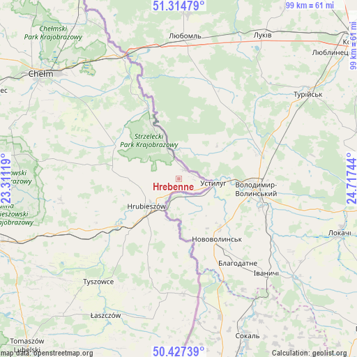
Hrebenne GPS coordinates[2]
50° 52' 23.52" North, 24° 0' 51.516" East
| Map corner | latitude | longitude |
|---|---|---|
| Upper-left | 51.31479°, | 23.31119° |
| Center: | 50.8732°, | 24.01431° |
| Lower-right: | 50.42739°, | 24.71744° |
| Map W x H: | 98.7×98.7 km | = 61.3×61.3mi |
| max Lat: | 54.83135° ⇑58.5% North |
| Hrebenne: | 50.8732° |
| min Lat: | ⇓41.5% South 49.21328° |
| min Long | Hrebenne | max Long |
| 14.20249° | 24.01431° | 24.03723° |
| W 99.9%⇐ | ⇒0.099999999999994% E |
Elevation
Elevation of Hrebenne is 197 m = 646 ft, and this is 5.6 m = 18 ft above average elevation for this country.
| Max E: |
974 m = 3196 ft | 41.1% |
| Hrebenne | 197 m 646 ft | |
| Avg. | 191.4 m = 628 ft | |
Min E: |
-3 m = -10 ft | 58.9% |
See also: Poland elevation on elevation.city.
Geographical zone
Hrebenne is located in North temperate zone (between Tropic of Cancer and the Arctic Circle). Distance of this North polar circle is 1744.6 km =1084 mi to North.| Distance of | km | miles | from Hrebenne |
|---|---|---|---|
| North Pole | 4350.5 | 2703.3 | to North |
| Arctic Circle | 1744.6 | 1084 | to North |
| Tropic Cancer | 3050.7 | 1895.6 | to South |
| Equator | 5656.6 | 3514.8 | to South |


Nearby cities:
15 places around Hrebenne: (largest is in red/bold)
• Białopole
23.5 km =14.6 mi,  302°
302°
• Dorohusk
34.6 km =21.5 mi,  334°
334°
• Dołhobyczów
32 km =19.9 mi,  177°
177°
• Dubienka
21.3 km =13.2 mi,  336°
336°
• Grabowiec
33.1 km =20.6 mi,  259°
259°
• Horodło
2.9 km =1.8 mi,  34°
34°
• Hrubieszów
11.4 km =7.1 mi,  228°
228°
• Jarosławiec
22.4 km =13.9 mi,  279°
279°
• Mircze
26 km =16.2 mi,  198°
198°
• Trzeszczany
20.3 km =12.6 mi,  253°
253°
• Tyszowce
36.1 km =22.4 mi,  217°
217°
• Uchanie
25.8 km =16 mi, 279°
• Werbkowice
22 km =13.7 mi, 232°
• Wojsławice
33.2 km =20.6 mi, 278°
• Żmudź
28.7 km =17.8 mi, 304°
Sources, notices
• [Note1] Compared only with cities in Poland existing in our database
• [Src1] Map data: © OpenStreetMap contributors (CC-BY-SA)
• [Src2] Other city data from geonames.org with taken over terms of usage.
• [Src3] Geographical zone / Annual Mean Temperature by Robert A. Rohde @ Wikipedia
