Mircze geodata
Mircze (Lublin) is a populated place; located in Poland in Europe/Warsaw (GMT+2) time zone. With population of 1,480 people, there are 1891 cities with bigger population in this country. Compared to other cities in Poland, 63.9% of cities are located further ↑North; 99.9% of cities are located further ←West and 63% of cities have lower elevation than Mircze. Note1


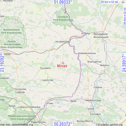
Mircze GPS coordinates[2]
50° 39' 5.904" North, 23° 53' 45.744" East
| Map corner | latitude | longitude |
|---|---|---|
| Upper-left | 51.09533°, | 23.19292° |
| Center: | 50.65164°, | 23.89604° |
| Lower-right: | 50.20372°, | 24.59917° |
| Map W x H: | 99.1×99.1 km | = 61.6×61.6mi |
| max Lat: | 54.83135° ⇑63.9% North |
| Mircze: | 50.65164° |
| min Lat: | ⇓36.1% South 49.21328° |
| min Long | Mircze | max Long |
| 14.20249° | 23.89604° | 24.03723° |
| W 99.9%⇐ | ⇒0.099999999999994% E |
Elevation
Elevation of Mircze is 209 m = 686 ft, and this is 17.6 m = 58 ft above average elevation for this country.
| Max E: |
974 m = 3196 ft | 37% |
| Mircze | 209 m 686 ft | |
| Avg. | 191.4 m = 628 ft | |
Min E: |
-3 m = -10 ft | 63% |
See also: Poland elevation on elevation.city.
Geographical zone
Mircze is located in North temperate zone (between Tropic of Cancer and the Arctic Circle). Distance of this North polar circle is 1769.2 km =1099.3 mi to North.| Distance of | km | miles | from Mircze |
|---|---|---|---|
| North Pole | 4375.1 | 2718.6 | to North |
| Arctic Circle | 1769.2 | 1099.3 | to North |
| Tropic Cancer | 3026 | 1880.3 | to South |
| Equator | 5631.9 | 3499.5 | to South |


Nearby cities:
15 places around Mircze: (largest is in red/bold)
• Dołhobyczów
12.3 km =7.6 mi,  126°
126°
• Grabowiec
30.7 km =19.1 mi,  307°
307°
• Horodło
28.8 km =17.9 mi,  20°
20°
• Hrebenne
26 km =16.2 mi, 18°
• Hrubieszów
17.1 km =10.6 mi,  359°
359°
• Komarów-Osada
29.6 km =18.4 mi,  265°
265°
• Michałów
23.7 km =14.7 mi,  240°
240°
• Miączyn
29.4 km =18.3 mi,  289°
289°
• Rachanie
27.7 km =17.2 mi, 242°
• Telatyn
14.4 km =8.9 mi,  196°
196°
• Trzeszczany
21.9 km =13.6 mi,  329°
329°
• Tyszowce
14.4 km =8.9 mi,  254°
254°
• Ulhówek
23.5 km =14.6 mi, 196°
• Werbkowice
14.7 km =9.1 mi,  320°
320°
• Łaszczów
17.8 km =11.1 mi,  222°
222°
Sources, notices
• [Note1] Compared only with cities in Poland existing in our database
• [Src1] Map data: © OpenStreetMap contributors (CC-BY-SA)
• [Src2] Other city data from geonames.org with taken over terms of usage.
• [Src3] Geographical zone / Annual Mean Temperature by Robert A. Rohde @ Wikipedia
