Waśniów geodata
Waśniów (Świętokrzyskie) is a seat of a third-order administrative division; located in Poland in Europe/Warsaw (GMT+2) time zone. With population of 460 people, there are 3556 cities with bigger population in this country. Compared to other cities in Poland, 57.8% of cities are located further ↑North; 76% of cities are located further ←West and 77.9% of cities have lower elevation than Waśniów. Note1


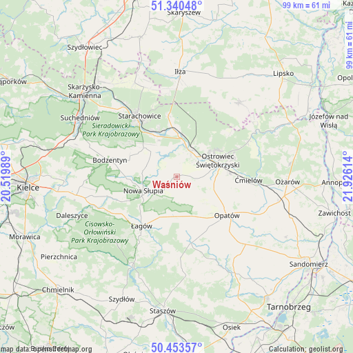
Waśniów GPS coordinates[2]
50° 53' 56.904" North, 21° 13' 22.836" East
| Map corner | latitude | longitude |
|---|---|---|
| Upper-left | 51.34048°, | 20.51989° |
| Center: | 50.89914°, | 21.22301° |
| Lower-right: | 50.45357°, | 21.92614° |
| Map W x H: | 98.6×98.6 km | = 61.3×61.3mi |
| max Lat: | 54.83135° ⇑57.8% North |
| Waśniów: | 50.89914° |
| min Lat: | ⇓42.2% South 49.21328° |
| min Long | Waśniów | max Long |
| 14.20249° | 21.22301° | 24.03723° |
| W 76%⇐ | ⇒24% E |
Elevation
Elevation of Waśniów is 257 m = 843 ft, and this is 65.6 m = 215 ft above average elevation for this country.
| Max E: |
974 m = 3196 ft | 22.1% |
| Waśniów | 257 m 843 ft | |
| Avg. | 191.4 m = 628 ft | |
Min E: |
-3 m = -10 ft | 77.9% |
See also: Poland elevation on elevation.city.
Geographical zone
Waśniów is located in North temperate zone (between Tropic of Cancer and the Arctic Circle). Distance of this North polar circle is 1741.7 km =1082.2 mi to North.| Distance of | km | miles | from Waśniów |
|---|---|---|---|
| North Pole | 4347.6 | 2701.5 | to North |
| Arctic Circle | 1741.7 | 1082.2 | to North |
| Tropic Cancer | 3053.5 | 1897.4 | to South |
| Equator | 5659.5 | 3516.6 | to South |


Nearby cities:
15 places around Waśniów: (largest is in red/bold)
• Adamów
14.3 km =8.9 mi,  338°
338°
• Baćkowice
11.9 km =7.4 mi,  176°
176°
• Brody
14 km =8.7 mi,  359°
359°
• Godów
8.1 km =5 mi, 342°
• Kunów
8 km =5 mi,  30°
30°
• Nowa Słupia
10.1 km =6.3 mi,  247°
247°
• Ostrowiec Świętokrzyski
11.9 km =7.4 mi,  73°
73°
• Pawłów
10 km =6.2 mi,  314°
314°
• Rzepin Drugi
11.6 km =7.2 mi,  320°
320°
• Rzepin Pierwszy
13.9 km =8.6 mi, 312°
• Sadowie
11.5 km =7.1 mi,  116°
116°
• Sosnówka
9.5 km =5.9 mi,  272°
272°
• Stara Słupia
7.6 km =4.7 mi, 250°
• Wiśniowa
13.9 km =8.6 mi,  222°
222°
• Wymysłów
11.5 km =7.1 mi,  47°
47°
Sources, notices
• [Note1] Compared only with cities in Poland existing in our database
• [Src1] Map data: © OpenStreetMap contributors (CC-BY-SA)
• [Src2] Other city data from geonames.org with taken over terms of usage.
• [Src3] Geographical zone / Annual Mean Temperature by Robert A. Rohde @ Wikipedia
