Stara Słupia geodata
Stara Słupia (Świętokrzyskie) is a populated place; located in Poland in Europe/Warsaw (GMT+2) time zone. With population of 921 people, there are 2633 cities with bigger population in this country. Compared to other cities in Poland, 58.4% of cities are located further ↑North; 74.7% of cities are located further ←West and 80.6% of cities have lower elevation than Stara Słupia. Note1


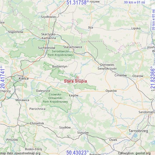
Stara Słupia GPS coordinates[2]
50° 52' 33.672" North, 21° 7' 13.908" East
| Map corner | latitude | longitude |
|---|---|---|
| Upper-left | 51.31758°, | 20.41741° |
| Center: | 50.87602°, | 21.12053° |
| Lower-right: | 50.43023°, | 21.82366° |
| Map W x H: | 98.7×98.7 km | = 61.3×61.3mi |
| max Lat: | 54.83135° ⇑58.4% North |
| Stara Słupia: | 50.87602° |
| min Lat: | ⇓41.6% South 49.21328° |
| min Long | Stara Słupia | max Long |
| 14.20249° | 21.12053° | 24.03723° |
| W 74.7%⇐ | ⇒25.3% E |
Elevation
Elevation of Stara Słupia is 268 m = 879 ft, and this is 76.6 m = 251 ft above average elevation for this country.
| Max E: |
974 m = 3196 ft | 19.4% |
| Stara Słupia | 268 m 879 ft | |
| Avg. | 191.4 m = 628 ft | |
Min E: |
-3 m = -10 ft | 80.6% |
See also: Poland elevation on elevation.city.
Geographical zone
Stara Słupia is located in North temperate zone (between Tropic of Cancer and the Arctic Circle). Distance of this North polar circle is 1744.3 km =1083.9 mi to North.| Distance of | km | miles | from Stara Słupia |
|---|---|---|---|
| North Pole | 4350.2 | 2703.1 | to North |
| Arctic Circle | 1744.3 | 1083.9 | to North |
| Tropic Cancer | 3051 | 1895.8 | to South |
| Equator | 5656.9 | 3515 | to South |


Nearby cities:
15 places around Stara Słupia: (largest is in red/bold)
• Adamów
16 km =9.9 mi,  7°
7°
• Baćkowice
12.2 km =7.6 mi,  140°
140°
• Bieliny
12.9 km =8 mi,  256°
256°
• Bodzentyn
13.5 km =8.4 mi,  302°
302°
• Godów
11.3 km =7 mi,  24°
24°
• Kunów
14.7 km =9.1 mi,  49°
49°
• Nowa Słupia
2.5 km =1.6 mi,  238°
238°
• Pawłów
9.6 km =6 mi,  0°
0°
• Rzepin Drugi
11.6 km =7.2 mi,  359°
359°
• Rzepin Pierwszy
12.3 km =7.6 mi,  345°
345°
• Sadowie
17.6 km =10.9 mi,  98°
98°
• Sosnówka
3.7 km =2.3 mi,  321°
321°
• Waśniów
7.6 km =4.7 mi,  70°
70°
• Wiśniowa
8 km =5 mi,  196°
196°
• Łagów
11.5 km =7.1 mi,  192°
192°
Sources, notices
• [Note1] Compared only with cities in Poland existing in our database
• [Src1] Map data: © OpenStreetMap contributors (CC-BY-SA)
• [Src2] Other city data from geonames.org with taken over terms of usage.
• [Src3] Geographical zone / Annual Mean Temperature by Robert A. Rohde @ Wikipedia
