Godów geodata
Godów (Świętokrzyskie) is a populated place; located in Poland in Europe/Warsaw (GMT+2) time zone. With population of 510 people, there are 3513 cities with bigger population in this country. Compared to other cities in Poland, 56% of cities are located further ↑North; 75.6% of cities are located further ←West and 72.4% of cities have lower elevation than Godów. Note1


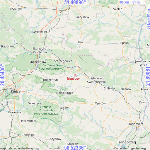
Godów GPS coordinates[2]
50° 58' 5.772" North, 21° 11' 14.928" East
| Map corner | latitude | longitude |
|---|---|---|
| Upper-left | 51.40896°, | 20.48436° |
| Center: | 50.96827°, | 21.18748° |
| Lower-right: | 50.52336°, | 21.89061° |
| Map W x H: | 98.5×98.5 km | = 61.2×61.2mi |
| max Lat: | 54.83135° ⇑56% North |
| Godów: | 50.96827° |
| min Lat: | ⇓44% South 49.21328° |
| min Long | Godów | max Long |
| 14.20249° | 21.18748° | 24.03723° |
| W 75.6%⇐ | ⇒24.4% E |
Elevation
Elevation of Godów is 237 m = 778 ft, and this is 45.6 m = 150 ft above average elevation for this country.
| Max E: |
974 m = 3196 ft | 27.6% |
| Godów | 237 m 778 ft | |
| Avg. | 191.4 m = 628 ft | |
Min E: |
-3 m = -10 ft | 72.4% |
See also: Poland elevation on elevation.city.
Geographical zone
Godów is located in North temperate zone (between Tropic of Cancer and the Arctic Circle). Distance of this North polar circle is 1734 km =1077.5 mi to North.| Distance of | km | miles | from Godów |
|---|---|---|---|
| North Pole | 4339.9 | 2696.7 | to North |
| Arctic Circle | 1734 | 1077.5 | to North |
| Tropic Cancer | 3061.2 | 1902.1 | to South |
| Equator | 5667.1 | 3521.4 | to South |


Nearby cities:
15 places around Godów: (largest is in red/bold)
• Adamów
6.3 km =3.9 mi,  334°
334°
• Bodzentyn
16.4 km =10.2 mi,  259°
259°
• Brody
6.7 km =4.2 mi,  20°
20°
• Kunów
6.6 km =4.1 mi,  96°
96°
• Nowa Słupia
13.4 km =8.3 mi,  210°
210°
• Ostrowiec Świętokrzyski
14.5 km =9 mi,  107°
107°
• Pawłów
4.7 km =2.9 mi, 261°
• Rzepin Drugi
5 km =3.1 mi,  284°
284°
• Rzepin Pierwszy
8 km =5 mi, 281°
• Sosnówka
10.1 km =6.3 mi,  223°
223°
• Stara Słupia
11.3 km =7 mi,  204°
204°
• Starachowice
11.2 km =7 mi,  313°
313°
• Waśniów
8.1 km =5 mi,  162°
162°
• Wymysłów
10.9 km =6.8 mi,  89°
89°
• Wąchock
17 km =10.6 mi, 313°
Sources, notices
• [Note1] Compared only with cities in Poland existing in our database
• [Src1] Map data: © OpenStreetMap contributors (CC-BY-SA)
• [Src2] Other city data from geonames.org with taken over terms of usage.
• [Src3] Geographical zone / Annual Mean Temperature by Robert A. Rohde @ Wikipedia
