Adamów geodata
Adamów (Świętokrzyskie) is a populated place; located in Poland in Europe/Warsaw (GMT+2) time zone. With population of 883 people, there are 2706 cities with bigger population in this country. Compared to other cities in Poland, 54.9% of cities are located further ↑North; 75.1% of cities are located further ←West and 76% of cities have lower elevation than Adamów. Note1


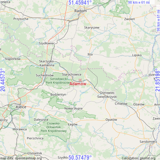
Adamów GPS coordinates[2]
51° 1' 9.156" North, 21° 8' 55.86" East
| Map corner | latitude | longitude |
|---|---|---|
| Upper-left | 51.45941°, | 20.44573° |
| Center: | 51.01921°, | 21.14885° |
| Lower-right: | 50.57479°, | 21.85198° |
| Map W x H: | 98.4×98.4 km | = 61.1×61.1mi |
| max Lat: | 54.83135° ⇑54.9% North |
| Adamów: | 51.01921° |
| min Lat: | ⇓45.1% South 49.21328° |
| min Long | Adamów | max Long |
| 14.20249° | 21.14885° | 24.03723° |
| W 75.1%⇐ | ⇒24.9% E |
Elevation
Elevation of Adamów is 250 m = 820 ft, and this is 58.6 m = 192 ft above average elevation for this country.
| Max E: |
974 m = 3196 ft | 24% |
| Adamów | 250 m 820 ft | |
| Avg. | 191.4 m = 628 ft | |
Min E: |
-3 m = -10 ft | 76% |
See also: Poland elevation on elevation.city.
Geographical zone
Adamów is located in North temperate zone (between Tropic of Cancer and the Arctic Circle). Distance of this North polar circle is 1728.4 km =1074 mi to North.| Distance of | km | miles | from Adamów |
|---|---|---|---|
| North Pole | 4334.3 | 2693.2 | to North |
| Arctic Circle | 1728.4 | 1074 | to North |
| Tropic Cancer | 3066.9 | 1905.7 | to South |
| Equator | 5672.8 | 3524.9 | to South |


Nearby cities:
15 places around Adamów: (largest is in red/bold)
• Bodzentyn
16 km =9.9 mi,  237°
237°
• Brody
5.1 km =3.2 mi,  83°
83°
• Godów
6.3 km =3.9 mi,  154°
154°
• Kunów
11.2 km =7 mi,  124°
124°
• Mirzec
14.3 km =8.9 mi,  333°
333°
• Pawłów
6.6 km =4.1 mi,  197°
197°
• Rzepin Drugi
4.9 km =3 mi,  206°
206°
• Rzepin Pierwszy
6.5 km =4 mi,  231°
231°
• Sosnówka
13.7 km =8.5 mi, 198°
• Stara Słupia
16 km =9.9 mi,  187°
187°
• Starachowice
5.8 km =3.6 mi,  290°
290°
• Waśniów
14.3 km =8.9 mi,  158°
158°
• Wielka Wieś
14 km =8.7 mi, 294°
• Wymysłów
14.7 km =9.1 mi,  112°
112°
• Wąchock
11.3 km =7 mi,  302°
302°
Sources, notices
• [Note1] Compared only with cities in Poland existing in our database
• [Src1] Map data: © OpenStreetMap contributors (CC-BY-SA)
• [Src2] Other city data from geonames.org with taken over terms of usage.
• [Src3] Geographical zone / Annual Mean Temperature by Robert A. Rohde @ Wikipedia
