Pawłów geodata
Pawłów (Świętokrzyskie) is a seat of a third-order administrative division; located in Poland in Europe/Warsaw (GMT+2) time zone. With population of 1,100 people, there are 2307 cities with bigger population in this country. Compared to other cities in Poland, 56.1% of cities are located further ↑North; 74.7% of cities are located further ←West and 80.6% of cities have lower elevation than Pawłów. Note1


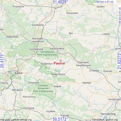
Pawłów GPS coordinates[2]
50° 57' 43.776" North, 21° 7' 14.232" East
| Map corner | latitude | longitude |
|---|---|---|
| Upper-left | 51.4029°, | 20.4175° |
| Center: | 50.96216°, | 21.12062° |
| Lower-right: | 50.5172°, | 21.82375° |
| Map W x H: | 98.5×98.5 km | = 61.2×61.2mi |
| max Lat: | 54.83135° ⇑56.1% North |
| Pawłów: | 50.96216° |
| min Lat: | ⇓43.9% South 49.21328° |
| min Long | Pawłów | max Long |
| 14.20249° | 21.12062° | 24.03723° |
| W 74.7%⇐ | ⇒25.3% E |
Elevation
Elevation of Pawłów is 268 m = 879 ft, and this is 76.6 m = 251 ft above average elevation for this country.
| Max E: |
974 m = 3196 ft | 19.4% |
| Pawłów | 268 m 879 ft | |
| Avg. | 191.4 m = 628 ft | |
Min E: |
-3 m = -10 ft | 80.6% |
See also: Poland elevation on elevation.city.
Geographical zone
Pawłów is located in North temperate zone (between Tropic of Cancer and the Arctic Circle). Distance of this North polar circle is 1734.7 km =1077.9 mi to North.| Distance of | km | miles | from Pawłów |
|---|---|---|---|
| North Pole | 4340.6 | 2697.1 | to North |
| Arctic Circle | 1734.7 | 1077.9 | to North |
| Tropic Cancer | 3060.5 | 1901.7 | to South |
| Equator | 5666.5 | 3521 | to South |


Nearby cities:
15 places around Pawłów: (largest is in red/bold)
• Adamów
6.6 km =4.1 mi,  17°
17°
• Bodzentyn
11.7 km =7.3 mi,  258°
258°
• Brody
9.9 km =6.2 mi,  45°
45°
• Godów
4.7 km =2.9 mi,  81°
81°
• Kunów
11.2 km =7 mi,  90°
90°
• Nowa Słupia
11.1 km =6.9 mi,  190°
190°
• Rzepin Drugi
2 km =1.2 mi,  354°
354°
• Rzepin Pierwszy
3.9 km =2.4 mi,  306°
306°
• Sosnówka
7 km =4.3 mi,  199°
199°
• Stara Słupia
9.6 km =6 mi,  180°
180°
• Starachowice
9.1 km =5.7 mi,  337°
337°
• Waśniów
10 km =6.2 mi,  134°
134°
• Wielka Wieś
16.2 km =10.1 mi,  318°
318°
• Wymysłów
15.6 km =9.7 mi, 87°
• Wąchock
14.5 km =9 mi,  328°
328°
Sources, notices
• [Note1] Compared only with cities in Poland existing in our database
• [Src1] Map data: © OpenStreetMap contributors (CC-BY-SA)
• [Src2] Other city data from geonames.org with taken over terms of usage.
• [Src3] Geographical zone / Annual Mean Temperature by Robert A. Rohde @ Wikipedia
