Brody geodata
Brody (Świętokrzyskie) is a seat of a third-order administrative division; located in Poland in Europe/Warsaw (GMT+2) time zone. With population of 1,737 people, there are 1653 cities with bigger population in this country. Compared to other cities in Poland, 54.7% of cities are located further ↑North; 76% of cities are located further ←West and 56.8% of cities have lower elevation than Brody. Note1


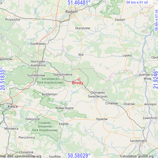
Brody GPS coordinates[2]
51° 1' 28.776" North, 21° 13' 17.292" East
| Map corner | latitude | longitude |
|---|---|---|
| Upper-left | 51.46481°, | 20.51835° |
| Center: | 51.02466°, | 21.22147° |
| Lower-right: | 50.58029°, | 21.9246° |
| Map W x H: | 98.3×98.3 km | = 61.1×61.1mi |
| max Lat: | 54.83135° ⇑54.7% North |
| Brody: | 51.02466° |
| min Lat: | ⇓45.3% South 49.21328° |
| min Long | Brody | max Long |
| 14.20249° | 21.22147° | 24.03723° |
| W 76%⇐ | ⇒24% E |
Elevation
Elevation of Brody is 190 m = 623 ft, and this is 1.4 m = 5 ft below average elevation for this country.
| Max E: |
974 m = 3196 ft | 43.2% |
| Avg. | 191.4 m = 628 ft | |
| Brody | 190 m = 623 ft | |
Min E: |
-3 m = -10 ft | 56.8% |
See also: Poland elevation on elevation.city.
Geographical zone
Brody is located in North temperate zone (between Tropic of Cancer and the Arctic Circle). Distance of this North polar circle is 1727.8 km =1073.6 mi to North.| Distance of | km | miles | from Brody |
|---|---|---|---|
| North Pole | 4333.7 | 2692.8 | to North |
| Arctic Circle | 1727.8 | 1073.6 | to North |
| Tropic Cancer | 3067.5 | 1906.1 | to South |
| Equator | 5673.4 | 3525.3 | to South |


Nearby cities:
15 places around Brody: (largest is in red/bold)
• Adamów
5.1 km =3.2 mi,  263°
263°
• Godów
6.7 km =4.2 mi,  200°
200°
• Iłża
15.4 km =9.6 mi,  4°
4°
• Kunów
8.1 km =5 mi,  149°
149°
• Mirzec
16.8 km =10.4 mi,  316°
316°
• Ostrowiec Świętokrzyski
15.6 km =9.7 mi,  132°
132°
• Pawłów
9.9 km =6.2 mi,  225°
225°
• Prędocin
15.6 km =9.7 mi,  28°
28°
• Rzepin Drugi
8.8 km =5.5 mi,  235°
235°
• Rzepin Pierwszy
11.2 km =7 mi,  245°
245°
• Sosnówka
16.5 km =10.3 mi,  214°
214°
• Starachowice
10.6 km =6.6 mi,  277°
277°
• Waśniów
14 km =8.7 mi,  179°
179°
• Wymysłów
10.5 km =6.5 mi, 125°
• Wąchock
15.6 km =9.7 mi,  290°
290°
Sources, notices
• [Note1] Compared only with cities in Poland existing in our database
• [Src1] Map data: © OpenStreetMap contributors (CC-BY-SA)
• [Src2] Other city data from geonames.org with taken over terms of usage.
• [Src3] Geographical zone / Annual Mean Temperature by Robert A. Rohde @ Wikipedia
