Sosnówka geodata
Sosnówka (Świętokrzyskie) is a populated place; located in Poland in Europe/Warsaw (GMT+2) time zone. With population of 660 people, there are 3145 cities with bigger population in this country. Compared to other cities in Poland, 57.6% of cities are located further ↑North; 74.3% of cities are located further ←West and 78.5% of cities have lower elevation than Sosnówka. Note1


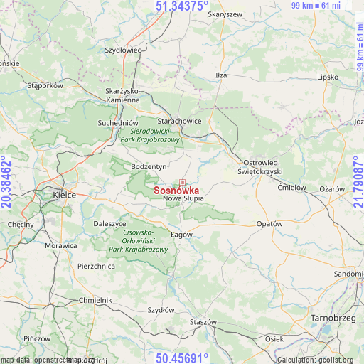
Sosnówka GPS coordinates[2]
50° 54' 8.784" North, 21° 5' 15.864" East
| Map corner | latitude | longitude |
|---|---|---|
| Upper-left | 51.34375°, | 20.38462° |
| Center: | 50.90244°, | 21.08774° |
| Lower-right: | 50.45691°, | 21.79087° |
| Map W x H: | 98.6×98.6 km | = 61.3×61.3mi |
| max Lat: | 54.83135° ⇑57.6% North |
| Sosnówka: | 50.90244° |
| min Lat: | ⇓42.4% South 49.21328° |
| min Long | Sosnówka | max Long |
| 14.20249° | 21.08774° | 24.03723° |
| W 74.3%⇐ | ⇒25.7% E |
Elevation
Elevation of Sosnówka is 259 m = 850 ft, and this is 67.6 m = 222 ft above average elevation for this country.
| Max E: |
974 m = 3196 ft | 21.5% |
| Sosnówka | 259 m 850 ft | |
| Avg. | 191.4 m = 628 ft | |
Min E: |
-3 m = -10 ft | 78.5% |
See also: Poland elevation on elevation.city.
Geographical zone
Sosnówka is located in North temperate zone (between Tropic of Cancer and the Arctic Circle). Distance of this North polar circle is 1741.4 km =1082.1 mi to North.| Distance of | km | miles | from Sosnówka |
|---|---|---|---|
| North Pole | 4347.2 | 2701.2 | to North |
| Arctic Circle | 1741.4 | 1082.1 | to North |
| Tropic Cancer | 3053.9 | 1897.6 | to South |
| Equator | 5659.8 | 3516.8 | to South |


Nearby cities:
15 places around Sosnówka: (largest is in red/bold)
• Adamów
13.7 km =8.5 mi,  18°
18°
• Baćkowice
15.9 km =9.9 mi,  140°
140°
• Bieliny
11.8 km =7.3 mi,  240°
240°
• Bodzentyn
10.1 km =6.3 mi,  295°
295°
• Godów
10.1 km =6.3 mi,  43°
43°
• Kunów
15 km =9.3 mi,  64°
64°
• Nowa Słupia
4.2 km =2.6 mi,  177°
177°
• Pawłów
7 km =4.3 mi, 19°
• Rzepin Drugi
8.9 km =5.5 mi,  13°
13°
• Rzepin Pierwszy
9 km =5.6 mi,  354°
354°
• Stara Słupia
3.7 km =2.3 mi, 141°
• Starachowice
15.1 km =9.4 mi,  355°
355°
• Waśniów
9.5 km =5.9 mi,  92°
92°
• Wiśniowa
10.7 km =6.6 mi, 179°
• Łagów
14.2 km =8.8 mi, 180°
Sources, notices
• [Note1] Compared only with cities in Poland existing in our database
• [Src1] Map data: © OpenStreetMap contributors (CC-BY-SA)
• [Src2] Other city data from geonames.org with taken over terms of usage.
• [Src3] Geographical zone / Annual Mean Temperature by Robert A. Rohde @ Wikipedia
