Kunów geodata
Kunów (Świętokrzyskie) is a seat of a third-order administrative division; located in Poland in Europe/Warsaw (GMT+2) time zone. With population of 3,078 people, there are 1029 cities with bigger population in this country. Compared to other cities in Poland, 56.1% of cities are located further ↑North; 76.7% of cities are located further ←West and 52% of cities have lower elevation than Kunów. Note1


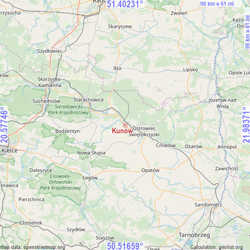
Kunów GPS coordinates[2]
50° 57' 41.616" North, 21° 16' 50.088" East
| Map corner | latitude | longitude |
|---|---|---|
| Upper-left | 51.40231°, | 20.57746° |
| Center: | 50.96156°, | 21.28058° |
| Lower-right: | 50.51659°, | 21.98371° |
| Map W x H: | 98.5×98.5 km | = 61.2×61.2mi |
| max Lat: | 54.83135° ⇑56.1% North |
| Kunów: | 50.96156° |
| min Lat: | ⇓43.9% South 49.21328° |
| min Long | Kunów | max Long |
| 14.20249° | 21.28058° | 24.03723° |
| W 76.7%⇐ | ⇒23.3% E |
Elevation
Elevation of Kunów is 177 m = 581 ft, and this is 14.4 m = 47 ft below average elevation for this country.
| Max E: |
974 m = 3196 ft | 48% |
| Avg. | 191.4 m = 628 ft | |
| Kunów | 177 m = 581 ft | |
Min E: |
-3 m = -10 ft | 52% |
See also: Poland elevation on elevation.city.
Geographical zone
Kunów is located in North temperate zone (between Tropic of Cancer and the Arctic Circle). Distance of this North polar circle is 1734.8 km =1078 mi to North.| Distance of | km | miles | from Kunów |
|---|---|---|---|
| North Pole | 4340.7 | 2697.2 | to North |
| Arctic Circle | 1734.8 | 1078 | to North |
| Tropic Cancer | 3060.5 | 1901.7 | to South |
| Equator | 5666.4 | 3520.9 | to South |


Nearby cities:
15 places around Kunów: (largest is in red/bold)
• Adamów
11.2 km =7 mi,  304°
304°
• Bodzechów
12.5 km =7.8 mi,  118°
118°
• Brody
8.1 km =5 mi,  329°
329°
• Brzóstowa
16.2 km =10.1 mi, 119°
• Godów
6.6 km =4.1 mi,  276°
276°
• Grójec
15.3 km =9.5 mi, 117°
• Ostrowiec Świętokrzyski
8.2 km =5.1 mi, 116°
• Pawłów
11.2 km =7 mi,  270°
270°
• Rzepin Drugi
11.6 km =7.2 mi, 280°
• Rzepin Pierwszy
14.5 km =9 mi, 279°
• Sadowie
13.6 km =8.5 mi,  152°
152°
• Sosnówka
15 km =9.3 mi,  244°
244°
• Stara Słupia
14.7 km =9.1 mi,  229°
229°
• Waśniów
8 km =5 mi,  210°
210°
• Wymysłów
4.4 km =2.7 mi,  78°
78°
Sources, notices
• [Note1] Compared only with cities in Poland existing in our database
• [Src1] Map data: © OpenStreetMap contributors (CC-BY-SA)
• [Src2] Other city data from geonames.org with taken over terms of usage.
• [Src3] Geographical zone / Annual Mean Temperature by Robert A. Rohde @ Wikipedia
