Sadowie geodata
Sadowie (Świętokrzyskie) is a seat of a third-order administrative division; located in Poland in Europe/Warsaw (GMT+2) time zone. With population of 600 people, there are 3270 cities with bigger population in this country. Compared to other cities in Poland, 59% of cities are located further ↑North; 77.7% of cities are located further ←West and 79.8% of cities have lower elevation than Sadowie. Note1


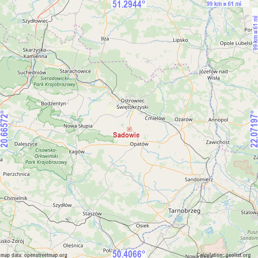
Sadowie GPS coordinates[2]
50° 51' 9.396" North, 21° 22' 7.824" East
| Map corner | latitude | longitude |
|---|---|---|
| Upper-left | 51.2944°, | 20.66572° |
| Center: | 50.85261°, | 21.36884° |
| Lower-right: | 50.4066°, | 22.07197° |
| Map W x H: | 98.7×98.7 km | = 61.3×61.3mi |
| max Lat: | 54.83135° ⇑59% North |
| Sadowie: | 50.85261° |
| min Lat: | ⇓41% South 49.21328° |
| min Long | Sadowie | max Long |
| 14.20249° | 21.36884° | 24.03723° |
| W 77.7%⇐ | ⇒22.3% E |
Elevation
Elevation of Sadowie is 265 m = 869 ft, and this is 73.6 m = 241 ft above average elevation for this country.
| Max E: |
974 m = 3196 ft | 20.2% |
| Sadowie | 265 m 869 ft | |
| Avg. | 191.4 m = 628 ft | |
Min E: |
-3 m = -10 ft | 79.8% |
See also: Poland elevation on elevation.city.
Geographical zone
Sadowie is located in North temperate zone (between Tropic of Cancer and the Arctic Circle). Distance of this North polar circle is 1746.9 km =1085.5 mi to North.| Distance of | km | miles | from Sadowie |
|---|---|---|---|
| North Pole | 4352.8 | 2704.7 | to North |
| Arctic Circle | 1746.9 | 1085.5 | to North |
| Tropic Cancer | 3048.4 | 1894.2 | to South |
| Equator | 5654.3 | 3513.4 | to South |


Nearby cities:
15 places around Sadowie: (largest is in red/bold)
• Baćkowice
11.7 km =7.3 mi,  234°
234°
• Bodzechów
7.7 km =4.8 mi,  38°
38°
• Brzóstowa
9 km =5.6 mi,  62°
62°
• Godów
18.1 km =11.2 mi,  315°
315°
• Grójec
8.9 km =5.5 mi, 55°
• Iwaniska
14.8 km =9.2 mi,  204°
204°
• Kunów
13.6 km =8.5 mi,  332°
332°
• Lipnik
16.2 km =10.1 mi,  147°
147°
• Opatów
7 km =4.3 mi, 145°
• Ostrowiec Świętokrzyski
8.6 km =5.3 mi,  7°
7°
• Stara Słupia
17.6 km =10.9 mi,  278°
278°
• Waśniów
11.5 km =7.1 mi,  296°
296°
• Wojciechowice
15.5 km =9.6 mi,  94°
94°
• Wymysłów
13.1 km =8.1 mi,  351°
351°
• Ćmielów
11 km =6.8 mi,  67°
67°
Sources, notices
• [Note1] Compared only with cities in Poland existing in our database
• [Src1] Map data: © OpenStreetMap contributors (CC-BY-SA)
• [Src2] Other city data from geonames.org with taken over terms of usage.
• [Src3] Geographical zone / Annual Mean Temperature by Robert A. Rohde @ Wikipedia
