Tylicz geodata
Tylicz (Lesser Poland) is a populated place; located in Poland in Europe/Warsaw (GMT+2) time zone. With population of 2,000 people, there are 1469 cities with bigger population in this country. Compared to other cities in Poland, 99.6% of cities are located further ↑North; 73% of cities are located further ←West and 98.6% of cities have lower elevation than Tylicz. Note1
Administrative division(s):
- Level 1: Lesser Poland
- Level 2: Powiat nowosądecki
- Level 3: Krynica-Zdrój


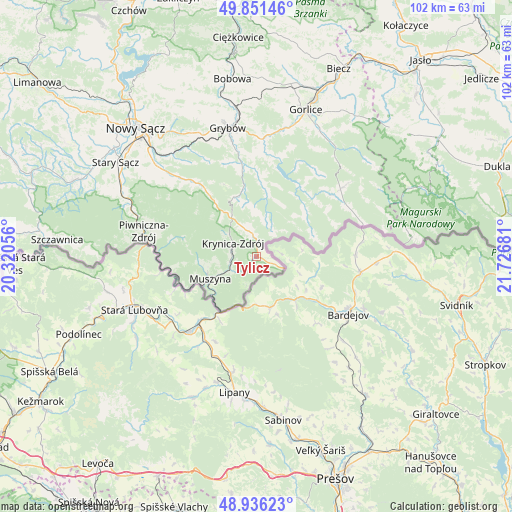
Tylicz GPS coordinates[2]
49° 23' 45.528" North, 21° 1' 25.248" East
| Map corner | latitude | longitude |
|---|---|---|
| Upper-left | 49.85146°, | 20.32056° |
| Center: | 49.39598°, | 21.02368° |
| Lower-right: | 48.93623°, | 21.72681° |
| Map W x H: | 101.8×101.8 km | = 63.3×63.3mi |
| max Lat: | 54.83135° ⇑99.6% North |
| Tylicz: | 49.39598° |
| min Lat: | ⇓0.4% South 49.21328° |
| min Long | Tylicz | max Long |
| 14.20249° | 21.02368° | 24.03723° |
| W 73%⇐ | ⇒27% E |
Elevation
Elevation of Tylicz is 587 m = 1926 ft, and this is 395.6 m = 1298 ft above average elevation for this country.
| Max E: |
974 m = 3196 ft | 1.4% |
| Tylicz | 587 m 1926 ft | |
| Avg. | 191.4 m = 628 ft | |
Min E: |
-3 m = -10 ft | 98.6% |
See also: Poland elevation on elevation.city.
Geographical zone
Tylicz is located in North temperate zone (between Tropic of Cancer and the Arctic Circle). Distance of this North polar circle is 1908.9 km =1186.1 mi to North.| Distance of | km | miles | from Tylicz |
|---|---|---|---|
| North Pole | 4514.7 | 2805.3 | to North |
| Arctic Circle | 1908.9 | 1186.1 | to North |
| Tropic Cancer | 2886.4 | 1793.5 | to South |
| Equator | 5492.3 | 3412.8 | to South |


Nearby cities:
15 places around Tylicz: (largest is in red/bold)
• Bystra
30 km =18.6 mi,  8°
8°
• Gorlice
30.5 km =19 mi,  18°
18°
• Grybów
26 km =16.2 mi,  347°
347°
• Kamionka Wielka
24 km =14.9 mi,  323°
323°
• Kobylanka
33.6 km =20.9 mi,  25°
25°
• Krynica-Zdrój
5.5 km =3.4 mi,  302°
302°
• Muszyna
10.2 km =6.3 mi,  244°
244°
• Nawojowa
28 km =17.4 mi,  312°
312°
• Piwniczna-Zdrój
22.9 km =14.2 mi,  282°
282°
• Ropa
21.8 km =13.5 mi,  3°
3°
• Rytro
27.8 km =17.3 mi,  291°
291°
• Stary Sącz
33.7 km =20.9 mi, 303°
• Sękowa
28.1 km =17.5 mi, 26°
• Uście Gorlickie
16.3 km =10.1 mi, 30°
• Łabowa
19.1 km =11.9 mi, 320°
Sources, notices
• [Note1] Compared only with cities in Poland existing in our database
• [Src1] Map data: © OpenStreetMap contributors (CC-BY-SA)
• [Src2] Other city data from geonames.org with taken over terms of usage.
• [Src3] Geographical zone / Annual Mean Temperature by Robert A. Rohde @ Wikipedia
