Krynica-Zdrój geodata
Krynica-Zdrój (Lesser Poland) is a populated place; located in Poland in Europe/Warsaw (GMT+2) time zone. With population of 12,270 people, there are 388 cities with bigger population in this country. Compared to other cities in Poland, 99.5% of cities are located further ↑North; 71.9% of cities are located further ←West and 98.6% of cities have lower elevation than Krynica-Zdrój. Note1
Administrative division(s):
- Level 1: Lesser Poland
- Level 2: Powiat nowosądecki
- Level 3: Krynica-Zdrój


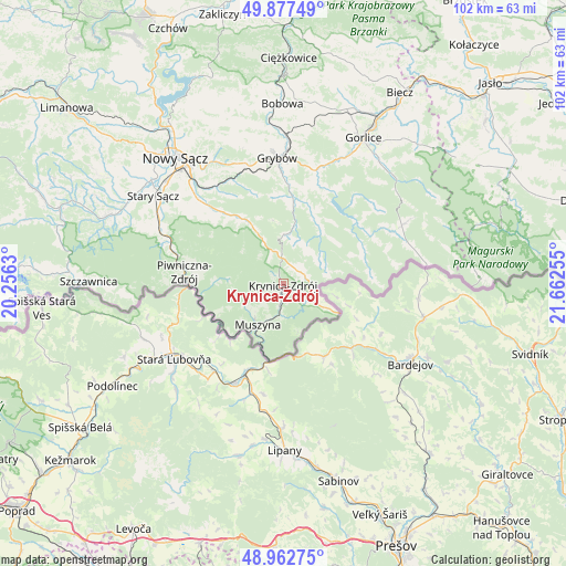
Krynica-Zdrój GPS coordinates[2]
49° 25' 20.1" North, 20° 57' 33.912" East
| Map corner | latitude | longitude |
|---|---|---|
| Upper-left | 49.87749°, | 20.2563° |
| Center: | 49.42225°, | 20.95942° |
| Lower-right: | 48.96275°, | 21.66255° |
| Map W x H: | 101.7×101.7 km | = 63.2×63.2mi |
| max Lat: | 54.83135° ⇑99.5% North |
| Krynica-Zdrój: | 49.42225° |
| min Lat: | ⇓0.5% South 49.21328° |
| min Long | Krynica-Zdrój | max Long |
| 14.20249° | 20.95942° | 24.03723° |
| W 71.9%⇐ | ⇒28.1% E |
Elevation
Elevation of Krynica-Zdrój is 592 m = 1942 ft, and this is 400.6 m = 1314 ft above average elevation for this country.
| Max E: |
974 m = 3196 ft | 1.4% |
| Krynica-Zdrój | 592 m 1942 ft | |
| Avg. | 191.4 m = 628 ft | |
Min E: |
-3 m = -10 ft | 98.6% |
See also: Poland elevation on elevation.city.
Geographical zone
Krynica-Zdrój is located in North temperate zone (between Tropic of Cancer and the Arctic Circle). Distance of this North polar circle is 1905.9 km =1184.3 mi to North.| Distance of | km | miles | from Krynica-Zdrój |
|---|---|---|---|
| North Pole | 4511.8 | 2803.5 | to North |
| Arctic Circle | 1905.9 | 1184.3 | to North |
| Tropic Cancer | 2889.3 | 1795.3 | to South |
| Equator | 5495.2 | 3414.6 | to South |


Nearby cities:
15 places around Krynica-Zdrój: (largest is in red/bold)
• Bystra
28.2 km =17.5 mi,  18°
18°
• Gorlice
29.7 km =18.5 mi,  29°
29°
• Grybów
22.5 km =14 mi,  357°
357°
• Kamionka Wielka
19 km =11.8 mi,  328°
328°
• Muszyna
8.6 km =5.3 mi,  211°
211°
• Nawojowa
22.6 km =14 mi,  315°
315°
• Nowy Sącz
29.2 km =18.1 mi, 319°
• Piwniczna-Zdrój
17.8 km =11.1 mi,  276°
276°
• Ropa
19.8 km =12.3 mi, 18°
• Rytro
22.4 km =13.9 mi,  289°
289°
• Stary Sącz
28.2 km =17.5 mi,  303°
303°
• Sękowa
28.1 km =17.5 mi,  37°
37°
• Tylicz
5.5 km =3.4 mi,  122°
122°
• Uście Gorlickie
17 km =10.6 mi,  49°
49°
• Łabowa
13.9 km =8.6 mi, 327°
Sources, notices
• [Note1] Compared only with cities in Poland existing in our database
• [Src1] Map data: © OpenStreetMap contributors (CC-BY-SA)
• [Src2] Other city data from geonames.org with taken over terms of usage.
• [Src3] Geographical zone / Annual Mean Temperature by Robert A. Rohde @ Wikipedia
