Muszyna geodata
Muszyna (Lesser Poland) is a populated place; located in Poland in Europe/Warsaw (GMT+2) time zone. With population of 5,018 people, there are 687 cities with bigger population in this country. Compared to other cities in Poland, 99.8% of cities are located further ↑North; 70.7% of cities are located further ←West and 96.4% of cities have lower elevation than Muszyna. Note1


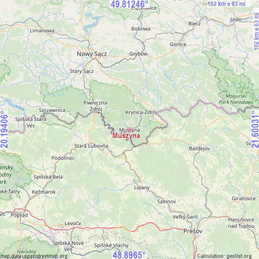
Muszyna GPS coordinates[2]
49° 21' 23.796" North, 20° 53' 49.848" East
| Map corner | latitude | longitude |
|---|---|---|
| Upper-left | 49.81246°, | 20.19406° |
| Center: | 49.35661°, | 20.89718° |
| Lower-right: | 48.8965°, | 21.60031° |
| Map W x H: | 101.8×101.8 km | = 63.3×63.3mi |
| max Lat: | 54.83135° ⇑99.8% North |
| Muszyna: | 49.35661° |
| min Lat: | ⇓0.2% South 49.21328° |
| min Long | Muszyna | max Long |
| 14.20249° | 20.89718° | 24.03723° |
| W 70.7%⇐ | ⇒29.3% E |
Elevation
Elevation of Muszyna is 451 m = 1480 ft, and this is 259.6 m = 852 ft above average elevation for this country.
| Max E: |
974 m = 3196 ft | 3.6% |
| Muszyna | 451 m 1480 ft | |
| Avg. | 191.4 m = 628 ft | |
Min E: |
-3 m = -10 ft | 96.4% |
See also: Poland elevation on elevation.city.
Geographical zone
Muszyna is located in North temperate zone (between Tropic of Cancer and the Arctic Circle). Distance of this North polar circle is 1913.2 km =1188.8 mi to North.| Distance of | km | miles | from Muszyna |
|---|---|---|---|
| North Pole | 4519.1 | 2808 | to North |
| Arctic Circle | 1913.2 | 1188.8 | to North |
| Tropic Cancer | 2882 | 1790.8 | to South |
| Equator | 5487.9 | 3410 | to South |


Nearby cities:
15 places around Muszyna: (largest is in red/bold)
• Grybów
30 km =18.6 mi,  7°
7°
• Kamionka Wielka
24.1 km =15 mi,  347°
347°
• Krynica-Zdrój
8.6 km =5.3 mi,  31°
31°
• Naszacowice
33.8 km =21 mi,  312°
312°
• Nawojowa
26 km =16.2 mi,  333°
333°
• Nowy Sącz
32.8 km =20.4 mi, 333°
• Piwniczna-Zdrój
16.2 km =10.1 mi, 305°
• Podegrodzie
33.1 km =20.6 mi,  317°
317°
• Ropa
28.2 km =17.5 mi,  22°
22°
• Rytro
22.3 km =13.9 mi, 311°
• Stary Sącz
29.8 km =18.5 mi, 320°
• Szczawnica
30.8 km =19.1 mi,  284°
284°
• Tylicz
10.2 km =6.3 mi,  64°
64°
• Uście Gorlickie
25.3 km =15.7 mi,  43°
43°
• Łabowa
19.3 km =12 mi, 350°
Sources, notices
• [Note1] Compared only with cities in Poland existing in our database
• [Src1] Map data: © OpenStreetMap contributors (CC-BY-SA)
• [Src2] Other city data from geonames.org with taken over terms of usage.
• [Src3] Geographical zone / Annual Mean Temperature by Robert A. Rohde @ Wikipedia
