Tuczępy geodata
Tuczępy (Świętokrzyskie) is a seat of a third-order administrative division; located in Poland in Europe/Warsaw (GMT+2) time zone. With population of 575 people, there are 3352 cities with bigger population in this country. Compared to other cities in Poland, 67% of cities are located further ↑North; 72.6% of cities are located further ←West and 65.9% of cities have lower elevation than Tuczępy. Note1


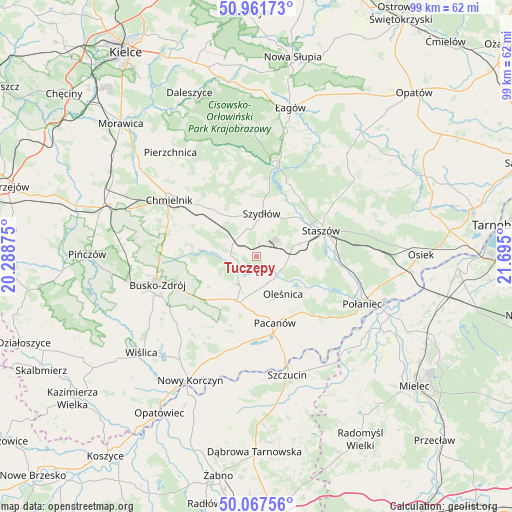
Tuczępy GPS coordinates[2]
50° 31' 0.336" North, 20° 59' 30.732" East
| Map corner | latitude | longitude |
|---|---|---|
| Upper-left | 50.96173°, | 20.28875° |
| Center: | 50.51676°, | 20.99187° |
| Lower-right: | 50.06756°, | 21.695° |
| Map W x H: | 99.4×99.4 km | = 61.8×61.8mi |
| max Lat: | 54.83135° ⇑67% North |
| Tuczępy: | 50.51676° |
| min Lat: | ⇓33% South 49.21328° |
| min Long | Tuczępy | max Long |
| 14.20249° | 20.99187° | 24.03723° |
| W 72.6%⇐ | ⇒27.4% E |
Elevation
Elevation of Tuczępy is 216 m = 709 ft, and this is 24.6 m = 81 ft above average elevation for this country.
| Max E: |
974 m = 3196 ft | 34.1% |
| Tuczępy | 216 m 709 ft | |
| Avg. | 191.4 m = 628 ft | |
Min E: |
-3 m = -10 ft | 65.9% |
See also: Poland elevation on elevation.city.
Geographical zone
Tuczępy is located in North temperate zone (between Tropic of Cancer and the Arctic Circle). Distance of this North polar circle is 1784.2 km =1108.7 mi to North.| Distance of | km | miles | from Tuczępy |
|---|---|---|---|
| North Pole | 4390.1 | 2727.9 | to North |
| Arctic Circle | 1784.2 | 1108.7 | to North |
| Tropic Cancer | 3011 | 1870.9 | to South |
| Equator | 5616.9 | 3490.2 | to South |


Nearby cities:
15 places around Tuczępy: (largest is in red/bold)
• Busko-Zdrój
20 km =12.4 mi,  255°
255°
• Chmielnik
20.1 km =12.5 mi,  302°
302°
• Gnojno
13.9 km =8.6 mi,  313°
313°
• Oleśnica
8.7 km =5.4 mi,  143°
143°
• Pacanów
13.4 km =8.3 mi,  164°
164°
• Raków
17.9 km =11.1 mi,  12°
12°
• Rytwiany
15.2 km =9.4 mi,  84°
84°
• Solec-Zdrój
18.3 km =11.4 mi,  203°
203°
• Staszów
13.3 km =8.3 mi,  67°
67°
• Stopnica
9.3 km =5.8 mi, 204°
• Szydłów
8.3 km =5.2 mi, 7°
• Słupia
15.2 km =9.4 mi,  167°
167°
• Widuchowa
14.1 km =8.8 mi, 257°
• Wiśniowa
20.2 km =12.6 mi, 65°
• Łubnice
16.2 km =10.1 mi, 136°
Sources, notices
• [Note1] Compared only with cities in Poland existing in our database
• [Src1] Map data: © OpenStreetMap contributors (CC-BY-SA)
• [Src2] Other city data from geonames.org with taken over terms of usage.
• [Src3] Geographical zone / Annual Mean Temperature by Robert A. Rohde @ Wikipedia
