Chmielnik geodata
Chmielnik (Świętokrzyskie) is a seat of a third-order administrative division; located in Poland in Europe/Warsaw (GMT+2) time zone. With population of 3,926 people, there are 830 cities with bigger population in this country. Compared to other cities in Poland, 64.8% of cities are located further ↑North; 68.5% of cities are located further ←West and 72.8% of cities have lower elevation than Chmielnik. Note1


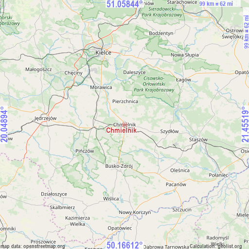
Chmielnik GPS coordinates[2]
50° 36' 51.84" North, 20° 45' 7.416" East
| Map corner | latitude | longitude |
|---|---|---|
| Upper-left | 51.05844°, | 20.04894° |
| Center: | 50.6144°, | 20.75206° |
| Lower-right: | 50.16612°, | 21.45519° |
| Map W x H: | 99.2×99.2 km | = 61.6×61.6mi |
| max Lat: | 54.83135° ⇑64.8% North |
| Chmielnik: | 50.6144° |
| min Lat: | ⇓35.2% South 49.21328° |
| min Long | Chmielnik | max Long |
| 14.20249° | 20.75206° | 24.03723° |
| W 68.5%⇐ | ⇒31.5% E |
Elevation
Elevation of Chmielnik is 239 m = 784 ft, and this is 47.6 m = 156 ft above average elevation for this country.
| Max E: |
974 m = 3196 ft | 27.2% |
| Chmielnik | 239 m 784 ft | |
| Avg. | 191.4 m = 628 ft | |
Min E: |
-3 m = -10 ft | 72.8% |
See also: Poland elevation on elevation.city.
Geographical zone
Chmielnik is located in North temperate zone (between Tropic of Cancer and the Arctic Circle). Distance of this North polar circle is 1773.4 km =1101.9 mi to North.| Distance of | km | miles | from Chmielnik |
|---|---|---|---|
| North Pole | 4379.3 | 2721.2 | to North |
| Arctic Circle | 1773.4 | 1101.9 | to North |
| Tropic Cancer | 3021.9 | 1877.7 | to South |
| Equator | 5627.8 | 3497 | to South |


Nearby cities:
15 places around Chmielnik: (largest is in red/bold)
• Brzeziny
21.6 km =13.4 mi,  324°
324°
• Busko-Zdrój
16.1 km =10 mi,  188°
188°
• Daleszyce
21.3 km =13.2 mi,  10°
10°
• Gnojno
7 km =4.3 mi,  100°
100°
• Imielno
21.7 km =13.5 mi,  261°
261°
• Kije
12.8 km =8 mi,  266°
266°
• Korytnica
17.4 km =10.8 mi,  286°
286°
• Morawica
17.5 km =10.9 mi,  327°
327°
• Pierzchnica
9.2 km =5.7 mi,  1°
1°
• Pińczów
19 km =11.8 mi,  236°
236°
• Raków
21.7 km =13.5 mi,  72°
72°
• Szydłów
18.2 km =11.3 mi, 98°
• Tuczępy
20.1 km =12.5 mi,  122°
122°
• Widuchowa
14.2 km =8.8 mi,  167°
167°
• Łukowa
19.4 km =12.1 mi,  309°
309°
Sources, notices
• [Note1] Compared only with cities in Poland existing in our database
• [Src1] Map data: © OpenStreetMap contributors (CC-BY-SA)
• [Src2] Other city data from geonames.org with taken over terms of usage.
• [Src3] Geographical zone / Annual Mean Temperature by Robert A. Rohde @ Wikipedia
