Stopnica geodata
Stopnica (Świętokrzyskie) is a seat of a third-order administrative division; located in Poland in Europe/Warsaw (GMT+2) time zone. With population of 1,545 people, there are 1807 cities with bigger population in this country. Compared to other cities in Poland, 68.6% of cities are located further ↑North; 71.2% of cities are located further ←West and 68.7% of cities have lower elevation than Stopnica. Note1


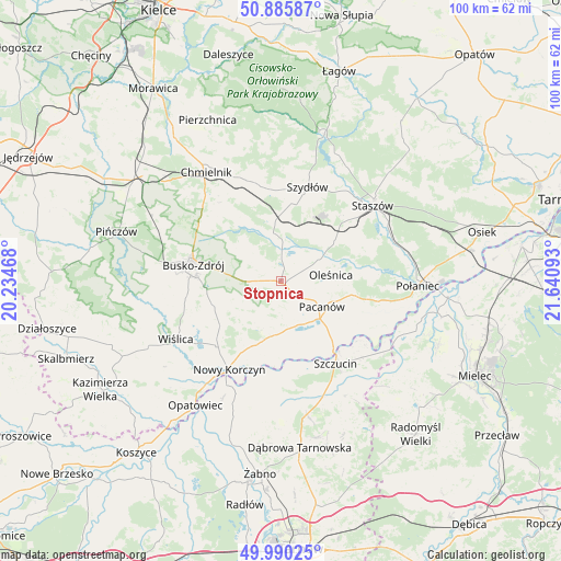
Stopnica GPS coordinates[2]
50° 26' 24.648" North, 20° 56' 16.08" East
| Map corner | latitude | longitude |
|---|---|---|
| Upper-left | 50.88587°, | 20.23468° |
| Center: | 50.44018°, | 20.9378° |
| Lower-right: | 49.99025°, | 21.64093° |
| Map W x H: | 99.6×99.6 km | = 61.9×61.9mi |
| max Lat: | 54.83135° ⇑68.6% North |
| Stopnica: | 50.44018° |
| min Lat: | ⇓31.4% South 49.21328° |
| min Long | Stopnica | max Long |
| 14.20249° | 20.9378° | 24.03723° |
| W 71.2%⇐ | ⇒28.8% E |
Elevation
Elevation of Stopnica is 225 m = 738 ft, and this is 33.6 m = 110 ft above average elevation for this country.
| Max E: |
974 m = 3196 ft | 31.3% |
| Stopnica | 225 m 738 ft | |
| Avg. | 191.4 m = 628 ft | |
Min E: |
-3 m = -10 ft | 68.7% |
See also: Poland elevation on elevation.city.
Geographical zone
Stopnica is located in North temperate zone (between Tropic of Cancer and the Arctic Circle). Distance of this North polar circle is 1792.8 km =1114 mi to North.| Distance of | km | miles | from Stopnica |
|---|---|---|---|
| North Pole | 4398.6 | 2733.2 | to North |
| Arctic Circle | 1792.8 | 1114 | to North |
| Tropic Cancer | 3002.5 | 1865.7 | to South |
| Equator | 5608.4 | 3484.9 | to South |


Nearby cities:
15 places around Stopnica: (largest is in red/bold)
• Bolesław
18.7 km =11.6 mi,  188°
188°
• Busko-Zdrój
15.9 km =9.9 mi,  282°
282°
• Gnojno
19.1 km =11.9 mi,  340°
340°
• Mędrzechów
17.6 km =10.9 mi,  177°
177°
• Nowy Korczyn
18 km =11.2 mi,  210°
210°
• Oleśnica
9.1 km =5.7 mi,  80°
80°
• Pacanów
8.6 km =5.3 mi,  121°
121°
• Solec-Zdrój
8.9 km =5.5 mi,  202°
202°
• Staszów
21.1 km =13.1 mi,  49°
49°
• Szczucin
17.5 km =10.9 mi,  146°
146°
• Szydłów
17.5 km =10.9 mi,  16°
16°
• Słupia
9.6 km =6 mi,  131°
131°
• Tuczępy
9.3 km =5.8 mi, 24°
• Widuchowa
11.4 km =7.1 mi,  299°
299°
• Łubnice
15.4 km =9.6 mi,  101°
101°
Sources, notices
• [Note1] Compared only with cities in Poland existing in our database
• [Src1] Map data: © OpenStreetMap contributors (CC-BY-SA)
• [Src2] Other city data from geonames.org with taken over terms of usage.
• [Src3] Geographical zone / Annual Mean Temperature by Robert A. Rohde @ Wikipedia
