Raków geodata
Raków (Świętokrzyskie) is a seat of a third-order administrative division; located in Poland in Europe/Warsaw (GMT+2) time zone. With population of 1,174 people, there are 2235 cities with bigger population in this country. Compared to other cities in Poland, 63.3% of cities are located further ↑North; 73.4% of cities are located further ←West and 67.4% of cities have lower elevation than Raków. Note1


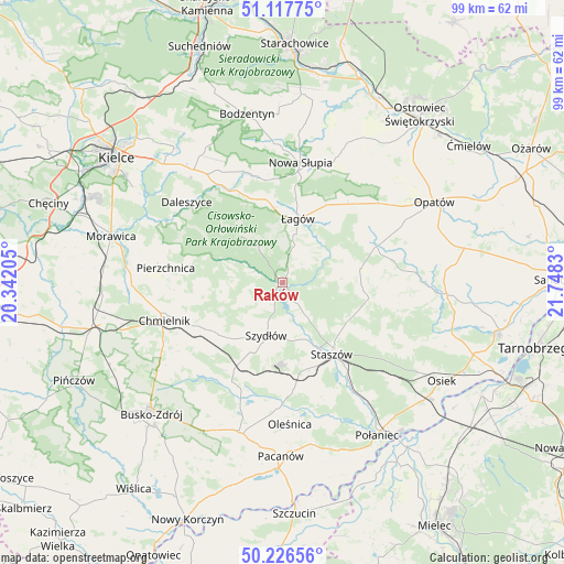
Raków GPS coordinates[2]
50° 40' 27.372" North, 21° 2' 42.612" East
| Map corner | latitude | longitude |
|---|---|---|
| Upper-left | 51.11775°, | 20.34205° |
| Center: | 50.67427°, | 21.04517° |
| Lower-right: | 50.22656°, | 21.7483° |
| Map W x H: | 99.1×99.1 km | = 61.6×61.6mi |
| max Lat: | 54.83135° ⇑63.3% North |
| Raków: | 50.67427° |
| min Lat: | ⇓36.7% South 49.21328° |
| min Long | Raków | max Long |
| 14.20249° | 21.04517° | 24.03723° |
| W 73.4%⇐ | ⇒26.6% E |
Elevation
Elevation of Raków is 221 m = 725 ft, and this is 29.6 m = 97 ft above average elevation for this country.
| Max E: |
974 m = 3196 ft | 32.6% |
| Raków | 221 m 725 ft | |
| Avg. | 191.4 m = 628 ft | |
Min E: |
-3 m = -10 ft | 67.4% |
See also: Poland elevation on elevation.city.
Geographical zone
Raków is located in North temperate zone (between Tropic of Cancer and the Arctic Circle). Distance of this North polar circle is 1766.7 km =1097.8 mi to North.| Distance of | km | miles | from Raków |
|---|---|---|---|
| North Pole | 4372.6 | 2717 | to North |
| Arctic Circle | 1766.7 | 1097.8 | to North |
| Tropic Cancer | 3028.5 | 1881.8 | to South |
| Equator | 5634.5 | 3501.1 | to South |


Nearby cities:
15 places around Raków: (largest is in red/bold)
• Baćkowice
18.6 km =11.6 mi,  45°
45°
• Bieliny
20.8 km =12.9 mi,  339°
339°
• Bogoria
15.3 km =9.5 mi,  99°
99°
• Chmielnik
21.7 km =13.5 mi,  252°
252°
• Gnojno
16 km =9.9 mi,  240°
240°
• Iwaniska
17.8 km =11.1 mi,  69°
69°
• Nowa Słupia
21.4 km =13.3 mi,  8°
8°
• Pierzchnica
20.6 km =12.8 mi,  277°
277°
• Rytwiany
19.7 km =12.2 mi,  144°
144°
• Staszów
15 km =9.3 mi,  145°
145°
• Szydłów
9.6 km =6 mi,  196°
196°
• Tuczępy
17.9 km =11.1 mi,  192°
192°
• Wiśniowa
15 km =9.3 mi, 11°
• Wiśniowa
17.1 km =10.6 mi,  121°
121°
• Łagów
11.6 km =7.2 mi, 13°
Sources, notices
• [Note1] Compared only with cities in Poland existing in our database
• [Src1] Map data: © OpenStreetMap contributors (CC-BY-SA)
• [Src2] Other city data from geonames.org with taken over terms of usage.
• [Src3] Geographical zone / Annual Mean Temperature by Robert A. Rohde @ Wikipedia
