Szydłów geodata
Szydłów (Świętokrzyskie) is a seat of a third-order administrative division; located in Poland in Europe/Warsaw (GMT+2) time zone. With population of 1,097 people, there are 2361 cities with bigger population in this country. Compared to other cities in Poland, 65.3% of cities are located further ↑North; 72.8% of cities are located further ←West and 77.2% of cities have lower elevation than Szydłów. Note1


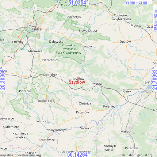
Szydłów GPS coordinates[2]
50° 35' 28.104" North, 21° 0' 24.48" East
| Map corner | latitude | longitude |
|---|---|---|
| Upper-left | 51.0354°, | 20.30368° |
| Center: | 50.59114°, | 21.0068° |
| Lower-right: | 50.14264°, | 21.70993° |
| Map W x H: | 99.3×99.3 km | = 61.7×61.7mi |
| max Lat: | 54.83135° ⇑65.3% North |
| Szydłów: | 50.59114° |
| min Lat: | ⇓34.7% South 49.21328° |
| min Long | Szydłów | max Long |
| 14.20249° | 21.0068° | 24.03723° |
| W 72.8%⇐ | ⇒27.2% E |
Elevation
Elevation of Szydłów is 255 m = 837 ft, and this is 63.6 m = 209 ft above average elevation for this country.
| Max E: |
974 m = 3196 ft | 22.8% |
| Szydłów | 255 m 837 ft | |
| Avg. | 191.4 m = 628 ft | |
Min E: |
-3 m = -10 ft | 77.2% |
See also: Poland elevation on elevation.city.
Geographical zone
Szydłów is located in North temperate zone (between Tropic of Cancer and the Arctic Circle). Distance of this North polar circle is 1776 km =1103.6 mi to North.| Distance of | km | miles | from Szydłów |
|---|---|---|---|
| North Pole | 4381.9 | 2722.8 | to North |
| Arctic Circle | 1776 | 1103.6 | to North |
| Tropic Cancer | 3019.3 | 1876.1 | to South |
| Equator | 5625.2 | 3495.3 | to South |


Nearby cities:
15 places around Szydłów: (largest is in red/bold)
• Bogoria
19.1 km =11.9 mi,  69°
69°
• Chmielnik
18.2 km =11.3 mi,  278°
278°
• Gnojno
11.2 km =7 mi, 276°
• Oleśnica
15.8 km =9.8 mi,  165°
165°
• Pacanów
21.4 km =13.3 mi, 173°
• Pierzchnica
21.3 km =13.2 mi,  303°
303°
• Raków
9.6 km =6 mi,  16°
16°
• Rytwiany
15.7 km =9.8 mi,  116°
116°
• Staszów
11.7 km =7.3 mi,  105°
105°
• Stopnica
17.5 km =10.9 mi,  196°
196°
• Tuczępy
8.3 km =5.2 mi,  187°
187°
• Widuchowa
18.6 km =11.6 mi,  232°
232°
• Wiśniowa
17.3 km =10.7 mi,  89°
89°
• Łagów
21.2 km =13.2 mi,  14°
14°
• Łubnice
22.4 km =13.9 mi,  153°
153°
Sources, notices
• [Note1] Compared only with cities in Poland existing in our database
• [Src1] Map data: © OpenStreetMap contributors (CC-BY-SA)
• [Src2] Other city data from geonames.org with taken over terms of usage.
• [Src3] Geographical zone / Annual Mean Temperature by Robert A. Rohde @ Wikipedia
