Wiśniowa geodata
Wiśniowa (Subcarpathian) is a populated place; located in Poland in Europe/Warsaw (GMT+2) time zone. With population of 870 people, there are 2725 cities with bigger population in this country. Compared to other cities in Poland, 82.5% of cities are located further ↑North; 81.8% of cities are located further ←West and 86.1% of cities have lower elevation than Wiśniowa. Note1
Administrative division(s):
- Level 1: Subcarpathian
- Level 2: Powiat ropczycko-sędziszowski
- Level 3: Iwierzyce


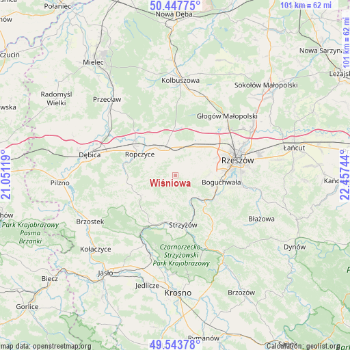
Wiśniowa GPS coordinates[2]
49° 59' 52.404" North, 21° 45' 15.516" East
| Map corner | latitude | longitude |
|---|---|---|
| Upper-left | 50.44775°, | 21.05119° |
| Center: | 49.99789°, | 21.75431° |
| Lower-right: | 49.54378°, | 22.45744° |
| Map W x H: | 100.5×100.5 km | = 62.4×62.4mi |
| max Lat: | 54.83135° ⇑82.5% North |
| Wiśniowa: | 49.99789° |
| min Lat: | ⇓17.5% South 49.21328° |
| min Long | Wiśniowa | max Long |
| 14.20249° | 21.75431° | 24.03723° |
| W 81.8%⇐ | ⇒18.2% E |
Elevation
Elevation of Wiśniowa is 296 m = 971 ft, and this is 104.6 m = 343 ft above average elevation for this country.
| Max E: |
974 m = 3196 ft | 13.9% |
| Wiśniowa | 296 m 971 ft | |
| Avg. | 191.4 m = 628 ft | |
Min E: |
-3 m = -10 ft | 86.1% |
See also: Poland elevation on elevation.city.
Geographical zone
Wiśniowa is located in North temperate zone (between Tropic of Cancer and the Arctic Circle). Distance of this North polar circle is 1841.9 km =1144.5 mi to North.| Distance of | km | miles | from Wiśniowa |
|---|---|---|---|
| North Pole | 4447.8 | 2763.7 | to North |
| Arctic Circle | 1841.9 | 1144.5 | to North |
| Tropic Cancer | 2953.3 | 1835.1 | to South |
| Equator | 5559.2 | 3454.3 | to South |


Nearby cities:
15 places around Wiśniowa: (largest is in red/bold)
• Babica
10.9 km =6.8 mi,  130°
130°
• Bystrzyca
2.9 km =1.8 mi,  219°
219°
• Czudec
8.6 km =5.3 mi, 133°
• Iwierzyce
3.5 km =2.2 mi,  359°
359°
• Kielanówka
12.9 km =8 mi,  75°
75°
• Krzywa
11.5 km =7.1 mi,  352°
352°
• Lutoryż
11.8 km =7.3 mi,  106°
106°
• Niechobrz
8.9 km =5.5 mi,  92°
92°
• Ropczyce
12 km =7.5 mi,  300°
300°
• Sędziszów Małopolski
9 km =5.6 mi,  334°
334°
• Trzciana
10.2 km =6.3 mi,  36°
36°
• Wielopole Skrzyńskie
11.5 km =7.1 mi,  239°
239°
• Zagórzyce
6 km =3.7 mi,  290°
290°
• Zarzecze
12.8 km =8 mi, 113°
• Zgłobień
7.4 km =4.6 mi, 77°
Sources, notices
• [Note1] Compared only with cities in Poland existing in our database
• [Src1] Map data: © OpenStreetMap contributors (CC-BY-SA)
• [Src2] Other city data from geonames.org with taken over terms of usage.
• [Src3] Geographical zone / Annual Mean Temperature by Robert A. Rohde @ Wikipedia
