Iwierzyce geodata
Iwierzyce (Subcarpathian) is a seat of a third-order administrative division; located in Poland in Europe/Warsaw (GMT+2) time zone. With population of 940 people, there are 2606 cities with bigger population in this country. Compared to other cities in Poland, 80.9% of cities are located further ↑North; 81.8% of cities are located further ←West and 72.4% of cities have lower elevation than Iwierzyce. Note1
Administrative division(s):
- Level 1: Subcarpathian
- Level 2: Powiat ropczycko-sędziszowski
- Level 3: Iwierzyce


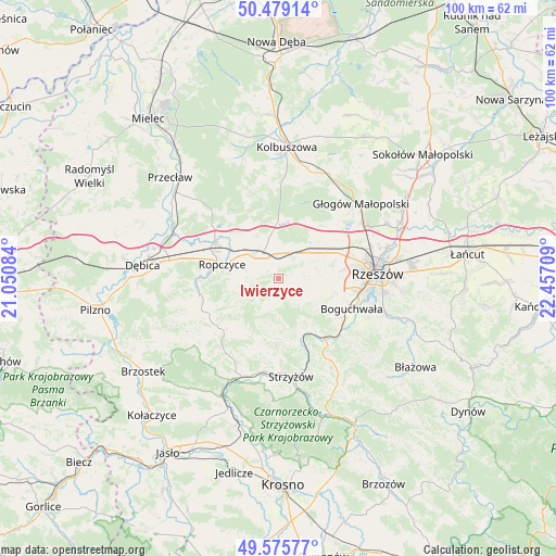
Iwierzyce GPS coordinates[2]
50° 1' 46.488" North, 21° 45' 14.256" East
| Map corner | latitude | longitude |
|---|---|---|
| Upper-left | 50.47914°, | 21.05084° |
| Center: | 50.02958°, | 21.75396° |
| Lower-right: | 49.57577°, | 22.45709° |
| Map W x H: | 100.4×100.4 km | = 62.4×62.4mi |
| max Lat: | 54.83135° ⇑80.9% North |
| Iwierzyce: | 50.02958° |
| min Lat: | ⇓19.1% South 49.21328° |
| min Long | Iwierzyce | max Long |
| 14.20249° | 21.75396° | 24.03723° |
| W 81.8%⇐ | ⇒18.2% E |
Elevation
Elevation of Iwierzyce is 237 m = 778 ft, and this is 45.6 m = 150 ft above average elevation for this country.
| Max E: |
974 m = 3196 ft | 27.6% |
| Iwierzyce | 237 m 778 ft | |
| Avg. | 191.4 m = 628 ft | |
Min E: |
-3 m = -10 ft | 72.4% |
See also: Poland elevation on elevation.city.
Geographical zone
Iwierzyce is located in North temperate zone (between Tropic of Cancer and the Arctic Circle). Distance of this North polar circle is 1838.4 km =1142.3 mi to North.| Distance of | km | miles | from Iwierzyce |
|---|---|---|---|
| North Pole | 4444.3 | 2761.6 | to North |
| Arctic Circle | 1838.4 | 1142.3 | to North |
| Tropic Cancer | 2956.8 | 1837.3 | to South |
| Equator | 5562.8 | 3456.6 | to South |


Nearby cities:
15 places around Iwierzyce: (largest is in red/bold)
• Babica
13.4 km =8.3 mi,  141°
141°
• Bystrzyca
6 km =3.7 mi,  197°
197°
• Czudec
11.3 km =7 mi,  146°
146°
• Kielanówka
12.5 km =7.8 mi,  91°
91°
• Krzywa
8 km =5 mi,  350°
350°
• Lutoryż
13.3 km =8.3 mi,  121°
121°
• Niechobrz
9.7 km =6 mi,  113°
113°
• Przybyszówka
12.4 km =7.7 mi,  80°
80°
• Ropczyce
10.7 km =6.6 mi,  283°
283°
• Sędziszów Małopolski
5.9 km =3.7 mi,  320°
320°
• Trzciana
7.7 km =4.8 mi,  52°
52°
• Wiśniowa
3.5 km =2.2 mi,  179°
179°
• Zagórzyce
5.8 km =3.6 mi,  255°
255°
• Zgłobień
7.5 km =4.7 mi,  104°
104°
• Świlcza
11.3 km =7 mi,  65°
65°
Sources, notices
• [Note1] Compared only with cities in Poland existing in our database
• [Src1] Map data: © OpenStreetMap contributors (CC-BY-SA)
• [Src2] Other city data from geonames.org with taken over terms of usage.
• [Src3] Geographical zone / Annual Mean Temperature by Robert A. Rohde @ Wikipedia
