Strachówka geodata
Strachówka (Mazovia) is a seat of a third-order administrative division; located in Poland in Europe/Warsaw (GMT+2) time zone. With population of 390 people, there are 3595 cities with bigger population in this country. Compared to other cities in Poland, 75.2% of cities are located further ↓South; 80.6% of cities are located further ←West and 74.5% of cities have higher elevation than Strachówka. Note1


Strachówka GPS coordinates[2]
52° 25' 36.912" North, 21° 38' 6" East
| Map corner | latitude | longitude |
|---|---|---|
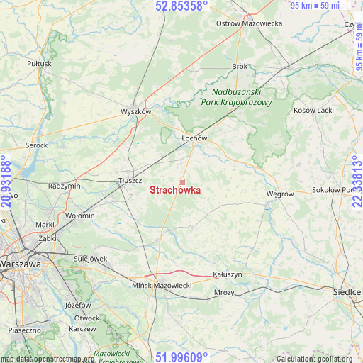
| Upper-left | 52.85358°, | 20.93188° |
| Center: | 52.42692°, | 21.635° |
| Lower-right: | 51.99609°, | 22.33813° |
| Map W x H: | 95.3×95.3 km | = 59.2×59.2mi |
| max Lat: | 54.83135° ⇑24.8% North |
| Strachówka: | 52.42692° |
| min Lat: | ⇓75.2% South 49.21328° |
| min Long | Strachówka | max Long |
| 14.20249° | 21.635° | 24.03723° |
| W 80.6%⇐ | ⇒19.4% E |
Elevation
Elevation of Strachówka is 112 m = 367 ft, and this is 79.4 m = 260 ft below average elevation for this country.
| Max E: |
974 m = 3196 ft | 74.5% |
| Avg. | 191.4 m = 628 ft | |
| Strachówka | 112 m = 367 ft | |
Min E: |
-3 m = -10 ft | 25.5% |
See also: Poland elevation on elevation.city.
Geographical zone
Strachówka is located in North temperate zone (between Tropic of Cancer and the Arctic Circle). Distance of this North polar circle is 1571.8 km =976.7 mi to North.| Distance of | km | miles | from Strachówka |
|---|---|---|---|
| North Pole | 4177.7 | 2595.9 | to North |
| Arctic Circle | 1571.8 | 976.7 | to North |
| Tropic Cancer | 3223.4 | 2002.9 | to South |
| Equator | 5829.3 | 3622.2 | to South |


Nearby cities:
15 places around Strachówka: (largest is in red/bold)
• Dobre
12.2 km =7.6 mi,  165°
165°
• Jadów
5.7 km =3.5 mi,  357°
357°
• Jasienica
15.2 km =9.4 mi,  264°
264°
• Klembów
20.7 km =12.9 mi, 263°
• Korytnica
14.6 km =9.1 mi,  95°
95°
• Ostrówek
16.4 km =10.2 mi,  31°
31°
• Ostrówek
18.6 km =11.6 mi, 257°
• Poświętne
18.1 km =11.2 mi,  233°
233°
• Rybno
22 km =13.7 mi,  315°
315°
• Stanisławów
16.4 km =10.2 mi,  201°
201°
• Tłuszcz
13.5 km =8.4 mi,  271°
271°
• Wierzbno
20 km =12.4 mi,  130°
130°
• Wiśniew
19.7 km =12.2 mi,  162°
162°
• Zabrodzie
17.4 km =10.8 mi,  302°
302°
• Łochów
12 km =7.5 mi,  15°
15°
Sources, notices
• [Note1] Compared only with cities in Poland existing in our database
• [Src1] Map data: © OpenStreetMap contributors (CC-BY-SA)
• [Src2] Other city data from geonames.org with taken over terms of usage.
• [Src3] Geographical zone / Annual Mean Temperature by Robert A. Rohde @ Wikipedia
