Jadów geodata
Jadów (Mazovia) is a populated place; located in Poland in Europe/Warsaw (GMT+2) time zone. With population of 1,200 people, there are 2164 cities with bigger population in this country. Compared to other cities in Poland, 76.2% of cities are located further ↓South; 80.5% of cities are located further ←West and 78.8% of cities have higher elevation than Jadów. Note1


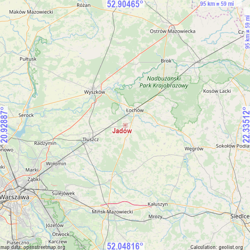
Jadów GPS coordinates[2]
52° 28' 42.564" North, 21° 37' 55.164" East
| Map corner | latitude | longitude |
|---|---|---|
| Upper-left | 52.90465°, | 20.92887° |
| Center: | 52.47849°, | 21.63199° |
| Lower-right: | 52.04816°, | 22.33512° |
| Map W x H: | 95.2×95.2 km | = 59.2×59.2mi |
| max Lat: | 54.83135° ⇑23.8% North |
| Jadów: | 52.47849° |
| min Lat: | ⇓76.2% South 49.21328° |
| min Long | Jadów | max Long |
| 14.20249° | 21.63199° | 24.03723° |
| W 80.5%⇐ | ⇒19.5% E |
Elevation
Elevation of Jadów is 102 m = 335 ft, and this is 89.4 m = 293 ft below average elevation for this country.
| Max E: |
974 m = 3196 ft | 78.8% |
| Avg. | 191.4 m = 628 ft | |
| Jadów | 102 m = 335 ft | |
Min E: |
-3 m = -10 ft | 21.2% |
See also: Poland elevation on elevation.city.
Geographical zone
Jadów is located in North temperate zone (between Tropic of Cancer and the Arctic Circle). Distance of this North polar circle is 1566.1 km =973.1 mi to North.| Distance of | km | miles | from Jadów |
|---|---|---|---|
| North Pole | 4172 | 2592.4 | to North |
| Arctic Circle | 1566.1 | 973.1 | to North |
| Tropic Cancer | 3229.1 | 2006.5 | to South |
| Equator | 5835.1 | 3625.8 | to South |


Nearby cities:
15 places around Jadów: (largest is in red/bold)
• Brańszczyk
17 km =10.6 mi,  349°
349°
• Dobre
17.8 km =11.1 mi,  169°
169°
• Jasienica
16.6 km =10.3 mi,  244°
244°
• Korytnica
16.4 km =10.2 mi,  115°
115°
• Ostrówek
12 km =7.5 mi,  46°
46°
• Ostrówek
20.5 km =12.7 mi, 241°
• Poświętne
21.9 km =13.6 mi,  220°
220°
• Rybno
18.2 km =11.3 mi,  303°
303°
• Stanisławów
21.8 km =13.5 mi,  195°
195°
• Stoczek
19.5 km =12.1 mi,  68°
68°
• Strachówka
5.7 km =3.5 mi,  177°
177°
• Tłuszcz
14.3 km =8.9 mi,  248°
248°
• Wyszków
17.3 km =10.7 mi,  317°
317°
• Zabrodzie
14.9 km =9.3 mi,  283°
283°
• Łochów
6.7 km =4.2 mi,  30°
30°
Sources, notices
• [Note1] Compared only with cities in Poland existing in our database
• [Src1] Map data: © OpenStreetMap contributors (CC-BY-SA)
• [Src2] Other city data from geonames.org with taken over terms of usage.
• [Src3] Geographical zone / Annual Mean Temperature by Robert A. Rohde @ Wikipedia
