Tarłów geodata
Tarłów (Świętokrzyskie) is a seat of a third-order administrative division; located in Poland in Europe/Warsaw (GMT+2) time zone. With population of 790 people, there are 2877 cities with bigger population in this country. Compared to other cities in Poland, 55.4% of cities are located further ↑North; 81.3% of cities are located further ←West and 54.2% of cities have higher elevation than Tarłów. Note1


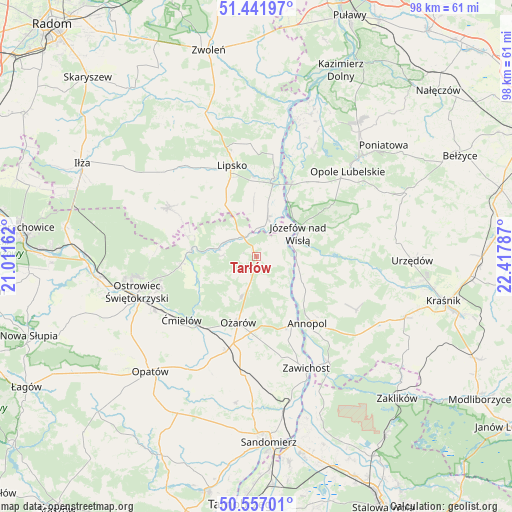
Tarłów GPS coordinates[2]
51° 0' 5.76" North, 21° 42' 53.064" East
| Map corner | latitude | longitude |
|---|---|---|
| Upper-left | 51.44197°, | 21.01162° |
| Center: | 51.0016°, | 21.71474° |
| Lower-right: | 50.55701°, | 22.41787° |
| Map W x H: | 98.4×98.4 km | = 61.1×61.1mi |
| max Lat: | 54.83135° ⇑55.4% North |
| Tarłów: | 51.0016° |
| min Lat: | ⇓44.6% South 49.21328° |
| min Long | Tarłów | max Long |
| 14.20249° | 21.71474° | 24.03723° |
| W 81.3%⇐ | ⇒18.7% E |
Elevation
Elevation of Tarłów is 161 m = 528 ft, and this is 30.4 m = 100 ft below average elevation for this country.
| Max E: |
974 m = 3196 ft | 54.2% |
| Avg. | 191.4 m = 628 ft | |
| Tarłów | 161 m = 528 ft | |
Min E: |
-3 m = -10 ft | 45.8% |
See also: Poland elevation on elevation.city.
Geographical zone
Tarłów is located in North temperate zone (between Tropic of Cancer and the Arctic Circle). Distance of this North polar circle is 1730.3 km =1075.2 mi to North.| Distance of | km | miles | from Tarłów |
|---|---|---|---|
| North Pole | 4336.2 | 2694.4 | to North |
| Arctic Circle | 1730.3 | 1075.2 | to North |
| Tropic Cancer | 3064.9 | 1904.4 | to South |
| Equator | 5670.8 | 3523.7 | to South |


Nearby cities:
15 places around Tarłów: (largest is in red/bold)
• Annopol
16.3 km =10.1 mi,  142°
142°
• Bałtów
12.1 km =7.5 mi,  278°
278°
• Bodzechów
22.1 km =13.7 mi,  241°
241°
• Brzóstowa
20.4 km =12.7 mi,  232°
232°
• Grójec
20.4 km =12.7 mi, 235°
• Józefów nad Wisłą
9.2 km =5.7 mi,  61°
61°
• Księżomierz
21.9 km =13.6 mi,  118°
118°
• Lipsko
18.1 km =11.2 mi,  345°
345°
• Ożarów
13.1 km =8.1 mi,  194°
194°
• Sienno
18.8 km =11.7 mi,  300°
300°
• Sobótka
23 km =14.3 mi, 186°
• Solec Nad Wisłą
15.4 km =9.6 mi,  13°
13°
• Wojciechowice
19.8 km =12.3 mi,  206°
206°
• Ćmielów
18.7 km =11.6 mi, 228°
• Łaziska
19.4 km =12.1 mi,  36°
36°
Sources, notices
• [Note1] Compared only with cities in Poland existing in our database
• [Src1] Map data: © OpenStreetMap contributors (CC-BY-SA)
• [Src2] Other city data from geonames.org with taken over terms of usage.
• [Src3] Geographical zone / Annual Mean Temperature by Robert A. Rohde @ Wikipedia
