Grójec geodata
Grójec (Świętokrzyskie) is a populated place; located in Poland in Europe/Warsaw (GMT+2) time zone. With population of 550 people, there are 3408 cities with bigger population in this country. Compared to other cities in Poland, 57.8% of cities are located further ↑North; 78.8% of cities are located further ←West and 52.9% of cities have higher elevation than Grójec. Note1


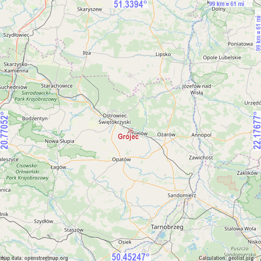
Grójec GPS coordinates[2]
50° 53' 52.98" North, 21° 28' 25.104" East
| Map corner | latitude | longitude |
|---|---|---|
| Upper-left | 51.3394°, | 20.77052° |
| Center: | 50.89805°, | 21.47364° |
| Lower-right: | 50.45247°, | 22.17677° |
| Map W x H: | 98.6×98.6 km | = 61.3×61.3mi |
| max Lat: | 54.83135° ⇑57.8% North |
| Grójec: | 50.89805° |
| min Lat: | ⇓42.2% South 49.21328° |
| min Long | Grójec | max Long |
| 14.20249° | 21.47364° | 24.03723° |
| W 78.8%⇐ | ⇒21.2% E |
Elevation
Elevation of Grójec is 164 m = 538 ft, and this is 27.4 m = 90 ft below average elevation for this country.
| Max E: |
974 m = 3196 ft | 52.9% |
| Avg. | 191.4 m = 628 ft | |
| Grójec | 164 m = 538 ft | |
Min E: |
-3 m = -10 ft | 47.1% |
See also: Poland elevation on elevation.city.
Geographical zone
Grójec is located in North temperate zone (between Tropic of Cancer and the Arctic Circle). Distance of this North polar circle is 1741.8 km =1082.3 mi to North.| Distance of | km | miles | from Grójec |
|---|---|---|---|
| North Pole | 4347.7 | 2701.5 | to North |
| Arctic Circle | 1741.8 | 1082.3 | to North |
| Tropic Cancer | 3053.4 | 1897.3 | to South |
| Equator | 5659.3 | 3516.5 | to South |


Nearby cities:
15 places around Grójec: (largest is in red/bold)
• Bałtów
14.3 km =8.9 mi,  20°
20°
• Bodzechów
2.8 km =1.7 mi,  291°
291°
• Brzóstowa
1 km =0.6 mi,  142°
142°
• Kunów
15.3 km =9.5 mi,  297°
297°
• Lipnik
18.8 km =11.7 mi,  175°
175°
• Opatów
11.4 km =7.1 mi,  197°
197°
• Ostrowiec Świętokrzyski
7.1 km =4.4 mi, 299°
• Ożarów
13.6 km =8.5 mi,  94°
94°
• Sadowie
8.9 km =5.5 mi,  235°
235°
• Sobótka
18.2 km =11.3 mi,  128°
128°
• Tarłów
20.4 km =12.7 mi,  55°
55°
• Waśniów
17.6 km =10.9 mi,  270°
270°
• Wojciechowice
10.2 km =6.3 mi, 127°
• Wymysłów
12.1 km =7.5 mi,  310°
310°
• Ćmielów
3 km =1.9 mi,  106°
106°
Sources, notices
• [Note1] Compared only with cities in Poland existing in our database
• [Src1] Map data: © OpenStreetMap contributors (CC-BY-SA)
• [Src2] Other city data from geonames.org with taken over terms of usage.
• [Src3] Geographical zone / Annual Mean Temperature by Robert A. Rohde @ Wikipedia
