Lipsko geodata
Lipsko (Mazovia) is a seat of a second-order administrative division; located in Poland in Europe/Warsaw (GMT+2) time zone. With population of 5,723 people, there are 627 cities with bigger population in this country. Compared to other cities in Poland, 50.1% of cities are located further ↑North; 80.6% of cities are located further ←West and 53.7% of cities have higher elevation than Lipsko. Note1


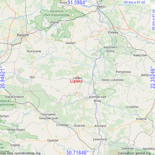
Lipsko GPS coordinates[2]
51° 9' 34.344" North, 21° 38' 57.588" East
| Map corner | latitude | longitude |
|---|---|---|
| Upper-left | 51.5984°, | 20.94621° |
| Center: | 51.15954°, | 21.64933° |
| Lower-right: | 50.71646°, | 22.35246° |
| Map W x H: | 98.1×98.1 km | = 61×61mi |
| max Lat: | 54.83135° ⇑50.1% North |
| Lipsko: | 51.15954° |
| min Lat: | ⇓49.9% South 49.21328° |
| min Long | Lipsko | max Long |
| 14.20249° | 21.64933° | 24.03723° |
| W 80.6%⇐ | ⇒19.4% E |
Elevation
Elevation of Lipsko is 162 m = 531 ft, and this is 29.4 m = 96 ft below average elevation for this country.
| Max E: |
974 m = 3196 ft | 53.7% |
| Avg. | 191.4 m = 628 ft | |
| Lipsko | 162 m = 531 ft | |
Min E: |
-3 m = -10 ft | 46.3% |
See also: Poland elevation on elevation.city.
Geographical zone
Lipsko is located in North temperate zone (between Tropic of Cancer and the Arctic Circle). Distance of this North polar circle is 1712.8 km =1064.3 mi to North.| Distance of | km | miles | from Lipsko |
|---|---|---|---|
| North Pole | 4318.7 | 2683.5 | to North |
| Arctic Circle | 1712.8 | 1064.3 | to North |
| Tropic Cancer | 3082.5 | 1915.4 | to South |
| Equator | 5688.4 | 3534.6 | to South |


Nearby cities:
15 places around Lipsko: (largest is in red/bold)
• Bałtów
17.3 km =10.7 mi,  205°
205°
• Chotcza
12.6 km =7.8 mi,  44°
44°
• Ciepielów
11.2 km =7 mi,  332°
332°
• Józefów nad Wisłą
18.2 km =11.3 mi,  136°
136°
• Kazanów
18.1 km =11.2 mi,  315°
315°
• Opole Lubelskie
22.3 km =13.9 mi,  93°
93°
• Przyłęk
17.9 km =11.1 mi,  22°
22°
• Rzeczniów
15 km =9.3 mi,  256°
256°
• Sienno
14.1 km =8.8 mi,  235°
235°
• Solec Nad Wisłą
8.5 km =5.3 mi,  107°
107°
• Tarłów
18.1 km =11.2 mi,  165°
165°
• Wielgie
14.1 km =8.8 mi,  310°
310°
• Wilków
19.6 km =12.2 mi,  54°
54°
• Zwoleń
22.2 km =13.8 mi,  348°
348°
• Łaziska
16.1 km =10 mi,  96°
96°
Sources, notices
• [Note1] Compared only with cities in Poland existing in our database
• [Src1] Map data: © OpenStreetMap contributors (CC-BY-SA)
• [Src2] Other city data from geonames.org with taken over terms of usage.
• [Src3] Geographical zone / Annual Mean Temperature by Robert A. Rohde @ Wikipedia
