Brzóstowa geodata
Brzóstowa (Świętokrzyskie) is a populated place; located in Poland in Europe/Warsaw (GMT+2) time zone. With population of 720 people, there are 3027 cities with bigger population in this country. Compared to other cities in Poland, 58% of cities are located further ↑North; 79% of cities are located further ←West and 50.2% of cities have lower elevation than Brzóstowa. Note1


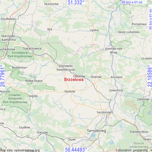
Brzóstowa GPS coordinates[2]
50° 53' 26.088" North, 21° 28' 57.828" East
| Map corner | latitude | longitude |
|---|---|---|
| Upper-left | 51.332°, | 20.77961° |
| Center: | 50.89058°, | 21.48273° |
| Lower-right: | 50.44493°, | 22.18586° |
| Map W x H: | 98.6×98.6 km | = 61.3×61.3mi |
| max Lat: | 54.83135° ⇑58% North |
| Brzóstowa: | 50.89058° |
| min Lat: | ⇓42% South 49.21328° |
| min Long | Brzóstowa | max Long |
| 14.20249° | 21.48273° | 24.03723° |
| W 79%⇐ | ⇒21% E |
Elevation
Elevation of Brzóstowa is 172 m = 564 ft, and this is 19.4 m = 64 ft below average elevation for this country.
| Max E: |
974 m = 3196 ft | 49.8% |
| Avg. | 191.4 m = 628 ft | |
| Brzóstowa | 172 m = 564 ft | |
Min E: |
-3 m = -10 ft | 50.2% |
See also: Poland elevation on elevation.city.
Geographical zone
Brzóstowa is located in North temperate zone (between Tropic of Cancer and the Arctic Circle). Distance of this North polar circle is 1742.7 km =1082.9 mi to North.| Distance of | km | miles | from Brzóstowa |
|---|---|---|---|
| North Pole | 4348.6 | 2702.1 | to North |
| Arctic Circle | 1742.7 | 1082.9 | to North |
| Tropic Cancer | 3052.6 | 1896.8 | to South |
| Equator | 5658.5 | 3516 | to South |


Nearby cities:
15 places around Brzóstowa: (largest is in red/bold)
• Bałtów
14.8 km =9.2 mi,  16°
16°
• Bodzechów
3.7 km =2.3 mi,  299°
299°
• Grójec
1 km =0.6 mi,  322°
322°
• Kunów
16.2 km =10.1 mi, 299°
• Lipnik
17.9 km =11.1 mi,  177°
177°
• Opatów
10.8 km =6.7 mi,  201°
201°
• Ostrowiec Świętokrzyski
8.1 km =5 mi, 302°
• Ożarów
12.9 km =8 mi,  91°
91°
• Sadowie
9 km =5.6 mi,  242°
242°
• Sobótka
17.2 km =10.7 mi,  127°
127°
• Waśniów
18.2 km =11.3 mi,  272°
272°
• Wilczyce
20.2 km =12.6 mi,  142°
142°
• Wojciechowice
9.2 km =5.7 mi, 125°
• Wymysłów
13.2 km =8.2 mi,  311°
311°
• Ćmielów
2.2 km =1.4 mi, 90°
Sources, notices
• [Note1] Compared only with cities in Poland existing in our database
• [Src1] Map data: © OpenStreetMap contributors (CC-BY-SA)
• [Src2] Other city data from geonames.org with taken over terms of usage.
• [Src3] Geographical zone / Annual Mean Temperature by Robert A. Rohde @ Wikipedia
