Wojciechowice geodata
Wojciechowice (Świętokrzyskie) is a seat of a third-order administrative division; located in Poland in Europe/Warsaw (GMT+2) time zone. With population of 324 people, there are 3615 cities with bigger population in this country. Compared to other cities in Poland, 59.4% of cities are located further ↑North; 80.1% of cities are located further ←West and 56.5% of cities have lower elevation than Wojciechowice. Note1
Administrative division(s):
- Level 1: Świętokrzyskie
- Level 2: Powiat opatowski
- Level 3: Wojciechowice


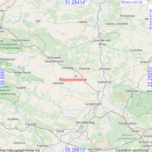
Wojciechowice GPS coordinates[2]
50° 50' 32.136" North, 21° 35' 21.912" East
| Map corner | latitude | longitude |
|---|---|---|
| Upper-left | 51.28414°, | 20.8863° |
| Center: | 50.84226°, | 21.58942° |
| Lower-right: | 50.39615°, | 22.29255° |
| Map W x H: | 98.7×98.7 km | = 61.3×61.3mi |
| max Lat: | 54.83135° ⇑59.4% North |
| Wojciechowice: | 50.84226° |
| min Lat: | ⇓40.6% South 49.21328° |
| min Long | Wojciechowice | max Long |
| 14.20249° | 21.58942° | 24.03723° |
| W 80.1%⇐ | ⇒19.9% E |
Elevation
Elevation of Wojciechowice is 189 m = 620 ft, and this is 2.4 m = 8 ft below average elevation for this country.
| Max E: |
974 m = 3196 ft | 43.5% |
| Avg. | 191.4 m = 628 ft | |
| Wojciechowice | 189 m = 620 ft | |
Min E: |
-3 m = -10 ft | 56.5% |
See also: Poland elevation on elevation.city.
Geographical zone
Wojciechowice is located in North temperate zone (between Tropic of Cancer and the Arctic Circle). Distance of this North polar circle is 1748 km =1086.2 mi to North.| Distance of | km | miles | from Wojciechowice |
|---|---|---|---|
| North Pole | 4353.9 | 2705.4 | to North |
| Arctic Circle | 1748 | 1086.2 | to North |
| Tropic Cancer | 3047.2 | 1893.4 | to South |
| Equator | 5653.1 | 3512.7 | to South |


Nearby cities:
15 places around Wojciechowice: (largest is in red/bold)
• Annopol
19.4 km =12.1 mi,  75°
75°
• Bodzechów
12.9 km =8 mi,  304°
304°
• Brzóstowa
9.2 km =5.7 mi,  305°
305°
• Dwikozy
18.3 km =11.4 mi,  130°
130°
• Grójec
10.2 km =6.3 mi, 307°
• Lipnik
14.2 km =8.8 mi,  208°
208°
• Obrazów
17.2 km =10.7 mi,  165°
165°
• Opatów
12.4 km =7.7 mi,  248°
248°
• Ostrowiec Świętokrzyski
17.3 km =10.7 mi, 304°
• Ożarów
7.4 km =4.6 mi,  46°
46°
• Sadowie
15.5 km =9.6 mi,  274°
274°
• Sobótka
8 km =5 mi, 130°
• Wilczyce
11.6 km =7.2 mi,  155°
155°
• Zawichost
19 km =11.8 mi,  101°
101°
• Ćmielów
7.5 km =4.7 mi,  315°
315°
Sources, notices
• [Note1] Compared only with cities in Poland existing in our database
• [Src1] Map data: © OpenStreetMap contributors (CC-BY-SA)
• [Src2] Other city data from geonames.org with taken over terms of usage.
• [Src3] Geographical zone / Annual Mean Temperature by Robert A. Rohde @ Wikipedia
